
Feature
Inside Louisiana’s Landmark Mississippi River Crossing
By Elena Hart · · 17 min read
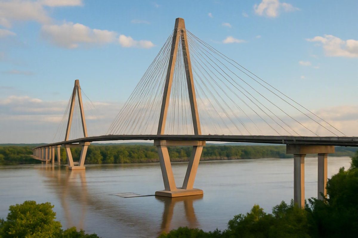
The John James Audubon Bridge is more than a conspicuous pair of towers above the Mississippi River. It is the central structure in a larger Louisiana transportation corridor that replaced a ferry-dependent connection, carried Louisiana Highway 10 across the river, and linked Pointe Coupee Parish with West Feliciana Parish.
Its significance comes from both scale and purpose. The cable-stayed main span is only one part of a long elevated bridge, which itself sits within a corridor of connecting roads, intersections, approaches and smaller structures. In practical terms, the project replaced a river crossing vulnerable to interruption with a permanent highway connection.
That distinction is essential to understanding the bridge. The main span, full bridge and wider road project have different dimensions and sometimes different reported costs. Historical facts such as the opening date can also be established more firmly than time-sensitive matters such as current restrictions, traffic conditions or modern span rankings.
John James Audubon Bridge at a glance
The John James Audubon Bridge is a cable-stayed highway bridge crossing the Mississippi River in south-central Louisiana. It stands northwest of Baton Rouge, between Pointe Coupee Parish on the west bank and West Feliciana Parish on the east bank. It is not located within Baton Rouge.
The bridge carries Louisiana Highway 10, usually written as LA 10. It connects the New Roads area west of the river with the St. Francisville area to the east, although its deck does not end in either town center.
The full formal name is John James Audubon Bridge. Searches and informal references often shorten it to John J. Audubon Bridge, while some historical material adds “Memorial.” Louisiana’s Department of Transportation and Development maintains the crossing.
John James Audubon Bridge facts
Feature Detail Route Louisiana Highway 10 River Mississippi River Parishes Pointe Coupee and West Feliciana Traffic opening May 5, 2011 Design Cable-stayed bridge Overall bridge length Approximately 12,883 feet Main span 1,583 feet Traffic lanes Four Towers Two, approximately 500 feet above the foundation tops Cable stays 136 Maintainer Louisiana Department of Transportation and Development
The route, traffic opening, overall length, main-span length, lane count and maintenance responsibility appear in a compiled structural summary of the bridge. The approximately 500-foot tower measurement is specifically taken from the tops of the foundations, as described in an engineering participant’s project account; other published sources use a roughly 520-foot figure measured from a different reference point.
The bridge’s appearance can make it seem like a self-contained monument. In reality, its towers and central span are the most visible elements of a much larger transportation system. That system includes elevated approaches, land-based road connections, intersections and other structures needed to carry LA 10 between the two sides of the river.
The route from New Roads to St. Francisville
From west to east, the official project begins at LA 10 in Pointe Coupee Parish, crosses the Mississippi River and terminates at US 61 just south of St. Francisville in West Feliciana Parish. Louisiana DOTD identifies the work as project H.009729 and says the project includes interchanges at both termini on its official John James Audubon Bridge project page.
This alignment explains why the bridge is routinely described as connecting New Roads and St. Francisville. Those communities are the principal geographic reference points, not the precise endpoints of the bridge deck. A traveler heading east approaches from the New Roads side, crosses the river on LA 10 and continues toward US 61 south of St. Francisville.
The wider corridor connects or intersects four important highways:
- LA 1 on the New Roads side
- LA 10, the route carried across the river
- LA 981, also known locally as River Road
- US 61 south of St. Francisville
The river bridge and its connecting roads have different cross sections. The elevated bridge carries four traffic lanes, while the connecting roadway was built predominantly with two travel lanes and provision for possible future widening.
They also have different lengths. The elevated bridge is approximately 2.44 miles long, while the project includes roughly 12 miles of connecting roadway. The bridge has two 11-foot travel lanes in each direction, 8-foot outside shoulders and 2-foot inside shoulders. The broader corridor also includes four intersections at LA 1, LA 10, LA 981 and US 61, according to the Zachary Taylor Parkway’s corridor description.
Those figures should not be combined casually. The approximately 2.44-mile measurement applies to the elevated bridge structure, while the roughly 12-mile figure concerns connecting roads beyond it. Sources may also define the limits of the broader project differently.
The completed corridor incorporated long approaches, secondary bridges, railroad-related work and terminal connections. Participant accounts disagree over whether the scope contained six, seven or eight additional bridges. The available record does not reconcile those counts, so assigning one definitive total would imply more certainty than the evidence supports.
The safest description is that the corridor contains:
- The cable-stayed Mississippi River crossing
- Long elevated approaches
- Approximately 12 miles of connecting roadway
- Connections or intersections involving four existing highways
- Multiple smaller structures
- A railroad overpass
- Interchanges at the project termini
This wider scope is also important when comparing construction costs. A figure for the main bridge cannot automatically be compared with an estimate covering connecting roads, interchanges, management and every secondary structure.
How a ferry shutdown accelerated the 2011 opening
The John James Audubon Bridge opened to vehicular traffic on May 5, 2011. High Mississippi River levels forced the New Roads–St. Francisville ferry to close, prompting Louisiana DOTD to place the new bridge into service earlier than planned.
The bridge did not function merely as a temporary alternative while the ferry waited to resume operation. It permanently replaced the ferry connection. A contemporary opening report recorded the high-water closure, accelerated opening and DOTD’s statement that the bridge was ready for traffic even though some project work remained (Louisiana Hometown opening report, May 5, 2011).
The practical change was fundamental. Before the bridge, travelers using the direct local crossing depended on a vessel whose operation could be interrupted by river conditions. After the opening, LA 10 provided a fixed highway connection between the two banks.
A concise construction and opening timeline is:
- April 2008: One engineering participant dates the start of active construction to this month.
- December 29, 2010: The advancing bridge structure was connected across the river.
- January 3, 2011: Installation of the final two stays brought the total to 136.
- May 5, 2011: High water closed the ferry, and the bridge opened to vehicle traffic earlier than planned.
Opening to traffic did not necessarily mean that every element of the wider corridor had been completed or formally accepted. The contemporary report attributes to DOTD’s chief engineer the judgment that the bridge was safe for traffic while acknowledging that some construction remained. The available evidence does not identify every unfinished item.
A personal bridge-reference page gives February 27, 2012, as the date construction concluded. Because stronger records in the evidence do not define that date as final acceptance, substantial completion or the end of all contract work, it should not displace May 5, 2011, as the verified traffic-opening date.
The accelerated opening demonstrates why the crossing matters as more than an engineering landmark. Its immediate purpose was practical: maintain cross-river mobility after river conditions made the established ferry connection unusable.
Dimensions and cable-stayed design explained
Four measurements are often compressed into one statement about how “long” the John James Audubon Bridge is:
- 1,583 feet: the cable-stayed main span between the principal towers.
- Approximately 12,883 feet: the overall bridge length.
- Approximately 2.44 miles: the overall elevated bridge expressed in miles.
- The wider corridor: the bridge plus approximately 12 miles of connecting roadway and associated infrastructure.
The 1,583-foot figure does not describe the full bridge. It is the principal river span. Likewise, the connecting-road mileage should not be added to the bridge length and presented as though every source defines the project from the same endpoints.
Deck width and traffic arrangement
The bridge has two 11-foot travel lanes in each direction. It also has 8-foot outside shoulders and 2-foot inside shoulders. Those shoulders are parts of the highway cross section and should not be described as dedicated bicycle lanes.
The connecting roadway is predominantly a two-lane facility, with provision for future widening. The evidence establishes those differing cross sections but does not supply a definitive official explanation for why the bridge and land approaches were configured differently.
Towers and stay system
Two H-shaped towers rise approximately 500 feet above the tops of their foundations. Some references instead publish a height of roughly 520 feet.
The towers support twin planes of stays. The bridge has 136 cable stays, and each stay contains between 20 and 69 galvanized, post-tensioned cables, according to Michael Baker International’s project description of the structure and stay system.
A cable-stayed bridge works differently from a classic suspension bridge. On the Audubon Bridge, inclined stays run more directly between the deck and towers.
Vertical clearance depends on the river
There is no single, unconditional clearance beneath the bridge because the Mississippi River’s surface elevation changes. Published structural figures give approximately 65 feet at high-water level, 76.2 feet at mean high-water level and 116.1 feet at low-water level.
A statement that the bridge simply “has 65 feet of clearance” therefore omits the high-water condition attached to that figure. Historical summaries are not a substitute for current official navigation information when a vessel operator needs an operational clearance.
A historical record claim, not a current ranking
Project sources used different record-setting descriptions around the 2011 opening. Depending on the publication, the bridge was called the longest cable-stayed span in North America, the longest in the Western Hemisphere or the second longest in the Western Hemisphere.
Those claims differ in geographic scope, date and possibly classification method. The most defensible formulation is that project participants described the 1,583-foot span as record-setting when it opened. The supplied evidence does not establish a present-day national, continental or global ranking.
Building a major bridge in the Mississippi River
The deck, stays and towers are only the visible portion of the engineering system. Before those components could carry traffic, the project team had to create foundations capable of transferring large structural loads through difficult riverbed conditions.
GM2, an engineering participant responsible for quality-control management and oversight, reports that the tower foundations used 10-foot-diameter, tip-grouted drilled shafts extending to depths of as much as approximately 200 feet. The same account describes a superstructure of precast concrete deck panels supported by a structural-steel frame of edge girders and floor beams in its engineering profile of the bridge.
Cofferdams and construction access
Project representatives also described the use of massive precast cofferdams. The contemporary opening report includes a participant’s description of precast units weighing approximately 5,000 tons being lowered into the Mississippi River.
The work required access beyond floating equipment. That temporary structure supported the logistics of building permanent foundations and superstructure components in a wide, active river.
These details come from organizations and representatives involved in the project. They are useful firsthand accounts of construction methods, but they are not independent proof that the project was trouble-free, ahead of schedule or under budget.
Steel framing and precast concrete deck panels
Above the foundations and towers, the cable-stayed superstructure combines precast concrete deck panels with structural-steel framing.
The principal components perform complementary functions:
- Edge girders run along the sides of the deck.
- Floor beams extend across the bridge and connect the edge framing.
- Precast concrete panels form the roadway deck and distribute vehicle loads into the steel structure.
- Cable stays transfer forces from the deck toward the towers.
- Towers and foundations carry those forces into the ground.
Project participant Michael Baker says weathering steel was used for the spans to reduce long-term maintenance requirements. Its use does not make a bridge maintenance-free.
Installing the stay system
The two towers carry twin planes of stays, producing the bridge’s characteristic fan-like profile.
All 136 stays were in place by January 3, 2011. Each stay consists of multiple galvanized, post-tensioned cables rather than one solid wire.
The deep shafts, cofferdams, temporary trestle, steel framing and staged stay installation illustrate why the crossing was more technically demanding than an ordinary land-based overpass. They do not establish whether the overall corridor met its original cost or schedule expectations.
Louisiana’s first design-build bridge project
Louisiana DOTD classifies the John James Audubon Bridge as a design-build project under project number H.009729.
It changes how contractual responsibility is organized.
Multiple organizations involved in the project describe the Audubon Bridge as Louisiana’s first design-build transportation project. Because this characterization comes primarily from project participants, it is best presented as an attributed project-history claim rather than as an independently audited institutional first.
The construction joint venture
Audubon Bridge Constructors was the design-build joint venture associated with construction. Its members were:
- Flatiron Constructors
- Granite Construction
- Parsons Transportation Group
It does not mean that every participating company performed every task.
The larger project organization included several distinct functions:
- Design and construction: Preparing detailed engineering and executing the permanent work.
- Program management: Coordinating schedule, scope and administration within the transportation program.
- Quality control: Checking whether design and construction complied with project requirements.
- Owner-representative oversight: Monitoring delivery on behalf of Louisiana DOTD.
- Quality assurance: Providing owner-directed or independent verification of quality systems and completed work.
GM2 says its complex-bridge team managed independent quality-control activities. Michael Baker describes its work as including program and construction management, owner-representative oversight and quality assurance. Those descriptions identify stated project roles; they do not mean either organization designed or constructed the entire corridor.
The TIMED program
The bridge was part of Louisiana’s Transportation Infrastructure Model for Economic Development, commonly abbreviated TIMED. A participant account says the program was created through 1989 state legislation, approved by voters and funded through a four-cent gasoline tax. That account also identifies Audubon Bridge Constructors and describes the bridge as the state’s first design-build project (GEC’s TIMED program profile).
The program context helps explain why the undertaking extended beyond the signature river span. Establishing the corridor required land approaches, road connections, intersections and secondary structures as well as the cable-stayed bridge.
Design-build also helps explain why published financial figures can refer to overlapping but nonidentical scopes. A proposal value for design and construction is not necessarily comparable with a wider program estimate that includes additional management, right-of-way or supporting work.
Why published cost figures do not match
The available evidence does not provide one authoritative, audited final cost covering a consistently defined scope. Published amounts range from approximately $347.9 million to approximately $409 million, but their source descriptions indicate that they measure different things.
| Published figure | Source description | Apparent scope |
|---|---|---|
| Approximately $347.9 million | Estimated successful proposal for design and construction (GEC project account) | Design-and-construction proposal rather than a verified final expenditure |
| $355 million | Construction cost and design-build project value (GM2 project profile) | Broad design-build work, including roadway approaches and multiple bridges |
| Approximately $408 million | Estimated total project cost (GEC project account) | Wider project estimate extending beyond the central river span |
| Approximately $409 million | Cost described by a project representative as being “in the area of” this amount in a contemporary opening report | Commonly cited overall-project figure, but not established here as an audited final total |
The approximately $347.9 million amount was reported as the estimated proposal for design and construction. A proposal value is not automatically the same as the amount ultimately spent. The $355 million figure comes from a participant describing the broader design-build project, including approaches and multiple structures.
The approximately $408 million figure was explicitly presented as an estimated total project cost. The approximately $409 million amount was stated around the opening by a project representative, but the available report does not provide an audited schedule explaining every included category.
Potential scope differences include:
- Main river-bridge construction
- The complete design-build contract
- Connecting roads and intersections
- Interchanges and secondary structures
- Railroad-related work
- Right-of-way or preconstruction expenses
- Program and construction management
- Owner oversight and quality assurance
- Changes made during delivery
- Administrative closeout and other corridor costs
These categories are not interchangeable. Without comparable baselines and final scopes, the figures cannot support a reliable calculation of cost overruns, underruns or savings.
The most defensible shorthand is that approximately $409 million is a commonly reported overall-project estimate. It should not be described as a verified, audited final expenditure without a Louisiana financial record defining the total’s scope.
Regional importance, the Audubon name, and the limits of the record
Project sources describe the John James Audubon Bridge as the only Mississippi River bridge in the approximately 90-river-mile interval between Baton Rouge, Louisiana, and Natchez, Mississippi.
That geography gives the crossing regional importance without requiring unsupported claims about economic growth, evacuation performance or development. A permanent bridge in such a long bridge-free interval changed the basic transportation map for people traveling between the New Roads and St. Francisville areas.
A closure can still expose the limited number of nearby alternatives. In January 2017, ice forced the bridge to close temporarily, and some motorists faced substantially longer routes through the Baton Rouge and Port Allen area. The bridge reopened that Saturday afternoon, according to WBRZ’s report on the January 2017 closure.
That event is a historical example, not evidence of current conditions. It does not establish that the bridge is now closed, routinely unsafe or subject to an ongoing winter restriction.
Why the bridge carries the Audubon name
The crossing is named for John James Audubon, the artist and naturalist associated with The Birds of America. Audubon worked in the St. Francisville area in 1821, providing the local connection behind the bridge’s name.
A later proposal sought to recognize Generals Robert H. Barrow and John A. Lejeune. Louisiana retained the Audubon name for the main bridge while naming the east approach for Barrow and the west approach for Lejeune. That legal distinction is reflected in the bridge’s compiled historical record.
Broader debates about Audubon’s biography and legacy are not necessary to explain the bridge’s route, construction or transportation purpose. For this bridge-focused account, the relevant naming fact is his documented association with the St. Francisville area.
Evidence boundary: what this record does not establish
The durable record supports the bridge’s location, route, dimensions, design, opening circumstances and ferry-replacement role. It does not establish:
- Current traffic volumes
- Current open or closed status
- Current toll status
- Present lane or vehicle restrictions
- Active maintenance work
- Official closure detours
- Current pedestrian or bicycle rules
- Current oversize-load requirements
- A present-day cable-stayed-span ranking
- A final audited project cost
- A definitive count of every ancillary structure
Travelers should consult current Louisiana DOTD traveler information and applicable official notices before relying on the bridge for an immediate trip, particularly during severe weather or when carrying an oversize or otherwise regulated load.
Frequently asked questions
Where is the John J. Audubon Bridge?
The John J. Audubon Bridge crosses the Mississippi River in south-central Louisiana, northwest of Baton Rouge. It connects Pointe Coupee Parish on the west bank with West Feliciana Parish on the east bank.
The bridge carries LA 10 between the New Roads and St. Francisville areas. Official project limits extend from LA 10 in Pointe Coupee Parish to US 61 just south of St. Francisville.
When did the John James Audubon Bridge open, and why was the opening accelerated?
The bridge opened to vehicles on May 5, 2011. High Mississippi River levels forced the New Roads–St. Francisville ferry to close, prompting Louisiana DOTD to place the bridge into service earlier than planned.
It permanently replaced the ferry rather than serving as a temporary alternative. Some work associated with the wider project remained after traffic began using the crossing.
How long is the bridge compared with its main span?
The complete elevated bridge is approximately 12,883 feet, or 2.44 miles, long. Its cable-stayed main span is 1,583 feet.
Those figures describe different parts of the structure. The wider corridor also includes approximately 12 miles of connecting roadway; that roadway is not part of the bridge-length measurement.
How much did the John James Audubon Bridge project cost?
No single amount in the available evidence can be verified as the final audited cost of a consistently defined project scope.
Published figures refer variously to a design-and-construction proposal, a design-build project value and broader overall-project estimates. Approximately $409 million is a recurring estimate for the wider undertaking, not a conclusively established audited expenditure.
Is the bridge still one of the longest cable-stayed spans?
The supplied evidence does not establish the bridge’s current ranking. Project sources described the span as record-setting around the time it opened, but they used different geographic categories.
A current national, continental or global ranking would require an up-to-date bridge dataset applying consistent structural definitions.
The John James Audubon Bridge’s lasting significance is practical as well as structural. It replaced a ferry-dependent connection with a permanent LA 10 crossing between two Louisiana parishes and filled a long gap in Mississippi River bridge access.
Its 1,583-foot cable-stayed main span is the centerpiece of a 12,883-foot elevated bridge and a substantially larger road corridor. Its May 2011 opening was shaped not only by the construction schedule but also by rising river levels that made the old ferry connection unusable.
Those historical facts are durable. Current operating conditions, restrictions, traffic volumes, modern rankings and a fully reconciled financial total require newer official Louisiana DOTD records.