 New York Know
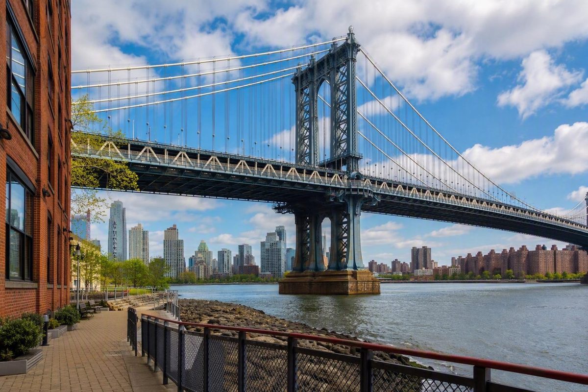
Manhattan Bridge at a glance
The Manhattan Bridge is a suspension bridge across the East River, linking Lower Manhattan with Downtown Brooklyn. Its Manhattan approach meets the Canal Street and Chinatown area, while its Brooklyn alignment reaches the Flatbush Avenue Extension. DUMBO is nearby and useful as a visitor reference, but it is not the bridge’s precise structural terminus.
Construction began in 1901, and the bridge opened to traffic on December 31, 1909. Leon Moisseiff designed the bridge, while Carrère and Hastings designed its monumental Manhattan entrance and plaza. The architects gave a heavily used transportation crossing the presence of a ceremonial civic gateway. The construction and opening dates are documented in Britannica’s Manhattan Bridge overview.
That combination captures what makes the Manhattan Bridge important. It is visually prominent and historically significant, but it is not simply an attraction. Its two-level structure accommodates road vehicles, subway trains, pedestrians, and cyclists.
Manhattan Bridge fact box
Fact Detail Location East River, between Lower Manhattan and Downtown Brooklyn Precise alignment Canal Street area to the Flatbush Avenue Extension Bridge type Suspension bridge Construction began 1901 Opening date December 31, 1909 Bridge designer Leon Moisseiff Manhattan entrance designers Carrère and Hastings Transportation modes Seven roadway lanes, four subway tracks, a pedestrian walkway, and a separate bikeway Toll status Toll-free Lower-level length 5,790 feet, abutment to abutment Upper-roadway length 6,090 feet, portal to portal Main span 1,470 feet Transportation configuration and endpoint-specific dimensions: NYC Department of Transportation. Toll status: NYC Tourism.
The ornate entrance, river setting, and proximity to well-visited neighborhoods make the bridge relevant to travelers. Its principal identity, however, is that of working infrastructure. Trains, vehicles, bicycles, and people on foot use it as part of ordinary movement between two boroughs. Understanding that daily role makes its engineering history—and its long record of rehabilitation—more meaningful.
For current official configuration, traffic, and dimensional figures, this overview gives priority to NYC DOT. Where references disagree about length or historical details, the differences are identified rather than silently reconciled.
How the bridge connects Manhattan and Brooklyn
Descriptions of the Manhattan Bridge’s location vary according to their purpose. An engineering or mapping description places its Manhattan end at Canal Street and its Brooklyn end at the Flatbush Avenue Extension. A visitor-oriented description is more likely to say that it connects Chinatown with Downtown Brooklyn, or sometimes Chinatown with DUMBO.
Those formulations are related, but they are not identical. Chinatown is an accurate neighborhood reference for the Manhattan approach. Downtown Brooklyn is the broader district reached by the Brooklyn alignment. DUMBO sits close enough to matter when planning a day on foot, but identifying it as the exact structural terminus sacrifices precision for familiarity.
The bridge does more than join two points on a map. It connects road networks, carries subway infrastructure across the East River, and provides direct borough-to-borough routes for pedestrians and cyclists. Different modes use different parts of the same broad, two-level structure.
The scale of that role is visible in NYC DOT’s 2024 daily averages: 70,293 vehicles, 3,413 pedestrians, and 6,391 cyclists. These figures establish the bridge as a major working crossing, but they do not predict how crowded a particular path, train, or roadway will be at a given hour. The counts are reported on the NYC DOT Manhattan Bridge page.
The crossing is toll-free, according to NYC Tourism. That statement concerns the Manhattan Bridge itself and should not be expanded into assumptions about other bridges, tunnels, road-pricing programs, or mode-specific policies.
The bridge also contains four subway tracks. Current service details are deliberately omitted because the trains using those tracks can change. Anyone planning a trip should consult current MTA information rather than treating a historical bridge overview as a live transit guide.
A precise cross-section is not included here. Although a simplified drawing could show the general principle of road, rail, pedestrian, and cycling functions distributed across two levels, it could also imply an inaccurate placement of tracks, lanes, paths, or structural members. Any publication-grade diagram should be checked against authoritative bridge plans before publication.
For a traveler, the practical lesson is straightforward. A person walking from Chinatown toward Brooklyn experiences the bridge as a linear route across the river. A subway passenger may cross it as one segment of a much longer journey. A cyclist or driver encounters it as part of a broader street network. All are using the same bridge, but not in the same way.
From proposal to opening: a concise history
The Brooklyn Bridge had already transformed movement between Manhattan and Brooklyn, and the Williamsburg Bridge was part of the broader expansion of cross-river capacity. The Manhattan Bridge became the next major suspension crossing in that sequence.
The proposal, naming history, transportation milestones, construction fatalities, and later designations below are reported by a tertiary historical overview of the Manhattan Bridge:
- 1898: The bridge was proposed.
- 1901: Construction began.
- 1902: The project, initially identified as Bridge No. 3, received the Manhattan Bridge name.
- December 31, 1909: The bridge opened to road traffic.
- 1912: Streetcars began operating across it.
- 1915: Subway service began.
- 1929: Streetcar operation ended.
- 1975: The Manhattan Bridge Arch and Colonnade received New York City landmark protection.
- 1983: The bridge was added to the New York State and National Registers of Historic Places.
- 2009: The American Society of Civil Engineers recognized it as a National Historic Civil Engineering Landmark.
The chronology shows that the bridge did not assume every later function on opening day. It began with road traffic and subsequently acquired streetcar and subway operations. By 1915, the essential components of its modern transportation identity were in place.
Leon Moisseiff is identified as the bridge’s designer. Construction administration involved multiple officials, engineers, contractors, and organizational changes, so it would be misleading to compress the project into a claim that one person or company was its sole builder. The clearer distinction is between Moisseiff’s design role and the larger network of people and organizations involved in executing the work.
NYC DOT describes the Manhattan Bridge as the youngest of the agency’s three East River suspension bridges. That relative youth matters because the bridge belongs to a period when engineers were reconsidering how much stiffness a suspension bridge required and how the structure itself could participate in responding to loads.
Construction was also dangerous. The tertiary account cited above reports that three workers died while working in the caisson for the Brooklyn-side tower. The fatalities deserve acknowledgment without becoming a detached dramatic aside. Caisson and foundation work formed only one part of a long construction effort, but the deaths remain part of the human cost behind the completed crossing.
The arrival of subway service made the bridge an especially dense multimodal corridor. The end of streetcar operation in 1929 did not turn it into a single-purpose structure; road and subway use continued, and the effects of carrying heavy rail traffic along the sides of a flexible bridge became more apparent over time.
The engineering idea behind the Manhattan Bridge
Vertical suspenders connect the deck to the main cables.
The Manhattan Bridge’s significance lies not simply in using that familiar system, but in the design theory behind how its components were expected to behave.
Earlier suspension-bridge design often emphasized heavy stiffening systems intended to resist deformation. Deflection theory took a different approach.
This did not mean that movement was irrelevant or that a bridge could bend without limits. It meant that structural response could become part of the design logic. A bridge could use less material than one dependent on a particularly heavy stiffening system, provided that its actual behavior remained within the design assumptions.
NYC DOT states that the Manhattan Bridge was the first bridge built on the basis of deflection theory. Leon Moisseiff applied the theory to the crossing and later assisted with the George Washington and Robert F. Kennedy bridges. Britannica traces the theory to engineer Joseph Melan and reports that its use reduced material, cost, and construction time.
The load path can be understood as a sequence:
- The deck, vehicles, trains, pedestrians, and cyclists create loads.
- Deck framing and truss members distribute those loads along and across the bridge.
- Vertical suspenders transfer them to the main suspension cables.
- The cables pass over the towers and continue toward the anchorages.
- The towers and anchorages transmit or resist the resulting forces.
Tertiary historical references describe four main cables and approximately 1,400 vertical suspender cables. The same material characterizes the Warren truss as a notable feature and reports that the Manhattan Bridge was the first suspension bridge to use one. Those details are best treated as attributed historical claims rather than uncontested conclusions drawn directly from original engineering plans.
Deflection theory was influential because it encouraged designers to understand suspension bridges as responsive structural systems. Yet the Manhattan Bridge also shows why a design innovation cannot be considered apart from its operating environment. A sound theory may still face demands that reveal vulnerabilities in a particular arrangement of loads.
The bridge’s technical importance received formal recognition in 2009, its centennial year, when the American Society of Civil Engineers named it a National Historic Civil Engineering Landmark. NYC DOT reports both the designation and the bridge’s pioneering use of deflection theory.
The recognition is appropriate because the Manhattan Bridge is not merely an early-twentieth-century object that happened to survive. It is evidence of an influential engineering idea placed into demanding daily service. Its later difficulties do not erase that contribution. They make the bridge more instructive by showing how innovation, operational loads, maintenance, and adaptation interact over time.
Why subway trains created a long-term structural challenge
The Manhattan Bridge’s flexibility was not inherently a design failure. Suspension bridges are expected to move under changing loads. The more consequential issue was how the structure responded when heavy subway trains loaded its sides unevenly.
A centered load affects a structure differently from a large load concentrated near one edge.
Saying simply that the trains were “too heavy” misses this distinction. Repeated uneven loading was associated with movement and structural wear that eventually demanded extensive inspection, repair, and reconstruction.
Britannica reports that renovations in 1940 revealed significant wear, attributed partly to subway operations, and that trains entering from opposite sides under particular conditions could produce movement of as much as eight feet. It is an attributed historical account of movement under a particular loading condition, as described in Britannica’s engineering history.
Additional renovation work began in 1978, and historical accounts describe extensive reconstruction between 1982 and 2004. The work was not one simple repair applied to one defective component. A large, old, intensively used bridge is a system of interacting structural, transportation, drainage, safety, and architectural elements.
NYC DOT’s documented rehabilitation scopes have included:
- structural and component rehabilitation;
- retrofitting transit floor beams on approach spans;
- repairing or replacing ornamental tower features;
- work on saddles, saddle housings, and anchorage housings;
- rehabilitation of truss members;
- drainage and deck-joint improvements;
- rehabilitation of fire-suppression equipment;
- replacement of walkway railing panels;
- walkway work; and
- preservation of historic and architectural elements.
These categories show the breadth of bridge stewardship. Some measures address load-carrying capacity. Others help prevent water from accelerating deterioration, maintain emergency equipment, improve barriers, or preserve character-defining details. On historic infrastructure, structural and architectural objectives must often be managed together.
An important source limitation applies to the project information on NYC DOT’s page. It includes a rehabilitation schedule with a stated completion date in 2021, but the supplied page does not establish the project’s current status. That dated schedule should not be used to claim that a particular contract is now active, complete, delayed, or responsible for present closures.
The larger lesson is that infrastructure rarely remains frozen at the moment of completion. Generations of actual subway operation revealed the cumulative effects of loading patterns that the bridge then had to accommodate. Engineers and transportation agencies were required to adapt the crossing without removing it from its essential role in the city.
Decades of rehabilitation are therefore not merely evidence of an unsuccessful bridge. They demonstrate how a heavily used structure evolves when operating demands expose weaknesses in its original configuration.
Architecture at the Manhattan entrance
The Manhattan Bridge presents two identities at once. Over the river, it is a plainly legible machine of towers, cables, suspenders, trusses, tracks, roadways, and paths. At the Manhattan approach, it becomes ceremonial: an elaborate stone portal, arch, colonnade, and plaza frame the transition between the street and the bridge.
Carrère and Hastings designed the monumental Manhattan entrance. The architectural partnership also designed the main branch of the New York Public Library. Its work at the bridge belongs to a similar civic language of ordered stonework, formal composition, and an emphasis on public arrival.
The entrance does not conceal the bridge’s utilitarian function. Instead, it announces that major infrastructure can also be civic architecture. The arch marks passage, the colonnade gives width and rhythm to the composition, and the plaza creates a formal threshold between the urban street network and the crossing.
That monumentality can seem surprising because the bridge’s everyday experience is so functional. Road traffic passes through the approaches, subway trains run across the structure, and pedestrian and cycling facilities serve transportation needs. The contrast is precisely the point: early-twentieth-century civic design could treat a public-works project as an opportunity for architectural dignity.
A tertiary account reports that the Manhattan Bridge Arch and Colonnade became a New York City landmark in 1975 and that the bridge was placed on the New York State and National Registers of Historic Places in 1983. These administrative statuses are attributed here to the Wikipedia overview, not presented as independently verified findings from the official designation records.
Those designations should not be confused with the American Society of Civil Engineers’ 2009 recognition. The arch-and-colonnade status concerns a significant architectural composition. The state and national register listings place the bridge within a broader historic framework. The civil-engineering designation recognizes its technical importance and association with deflection theory.
Together, the recognitions help explain why rehabilitation must involve more than keeping trains and vehicles moving. Work may also need to account for ornamental features, historic materials, visual character, and the relationship between the bridge and its approaches. Preservation is not an alternative to structural repair; on a bridge of this importance, it becomes one of the conditions under which repair is planned.
For visitors, the Manhattan entrance offers the clearest expression of the bridge’s civic ambition. The crossing is not only a span from one shore to another. It is an engineered transportation corridor given an architectural front door.
How long is the Manhattan Bridge? Why the published figures differ
The Manhattan Bridge does not have one universally interchangeable “length.” A reported length depends on what is being measured: the suspended main span, the structure between abutments, the distance between roadway portals, or a longer total that may include a different extent of the approaches.
| Figure | Endpoints or definition | Reported source |
|---|---|---|
| 5,790 feet | Lower level, abutment to abutment | NYC DOT |
| 6,090 feet | Upper roadway, portal to portal | NYC DOT |
| 1,470 feet | Main span | NYC DOT |
| 6,855 feet | Commonly reported total; endpoints unspecified in the supplied references | Britannica, Wikipedia, and Apple Maps |
| 1,480 feet | Alternative reported main-span figure | Wikipedia |
NYC DOT’s first two totals can both be correct because an abutment and a portal are not the same type of endpoint. Measuring one level between abutments therefore need not produce the same distance as measuring another between portals.
The main span is a different measurement again. When presenting NYC DOT’s official figure, this article uses 1,470 feet. The alternative 1,480-foot value remains a source-comparison note rather than a silent substitute.
The frequently published total of 6,855 feet is longer than either of NYC DOT’s endpoint-specific totals. Apple Maps identifies the Canal Street–to–Flatbush Avenue Extension alignment while listing that total in its Manhattan Bridge place description. The supplied material does not define precisely where that measurement begins and ends.
That does not make 6,855 feet necessarily wrong. It makes the figure incomplete without an endpoint definition. It may use a different extent of the approaches or another measurement convention. Without primary dimensional plans identifying its endpoints, it should not be treated as interchangeable with the lower-level or upper-roadway figures.
The same caution applies to the ten-foot difference between the reported main-span values. Rounding, historical conventions, or different structural reference points might explain it, but none of those possibilities should be asserted without documentation.
A definitive tower height is omitted for the same reason. The supplied tertiary historical source gives internally inconsistent tower-height figures, so selecting one would create an appearance of certainty that the evidence does not justify.
The practical answer is therefore:
- “Length” must be defined by its endpoints.
- NYC DOT’s lower-level and upper-roadway measurements describe different parts of the crossing.
- The main span is not the same as the bridge’s total length.
- The commonly quoted 6,855-foot total should remain qualified until its measurement basis is clear.
Infrastructure figures become more useful when their definitions remain attached. A single unlabeled number may look simple, but it conceals the geometry of a bridge with multiple levels, approaches, portals, and structural boundaries.
What visitors can expect from a crossing
The stable practical fact is that the Manhattan Bridge accommodates pedestrians and cyclists. NYC DOT describes a pedestrian walkway and a separate bikeway as part of the bridge’s transportation arrangement.
NYC Tourism lists the Manhattan-side entrance at Bowery between Canal and Bayard Streets. That is a useful starting point, but it is not a complete turn-by-turn guide and does not establish the present Brooklyn-side entrance, current path conditions, operating hours, temporary restrictions, or accessibility of the complete route.
A crossing can fit naturally into an area-based day. On the Manhattan side, the bridge meets Chinatown rather than the southern core of the Financial District. On the Brooklyn side, it feeds into Downtown Brooklyn, with DUMBO nearby. The bridge can therefore function as a transition between areas rather than as an isolated attraction requiring an immediate return trip.
A traveler spending the day in Lower Manhattan might finish in or around Chinatown and use the bridge as the next movement toward Brooklyn. Someone beginning in Brooklyn can use it to arrive in Chinatown. The point is not to prescribe a precise itinerary, but to recognize that the bridge works best when it connects districts a traveler already intends to explore.
That approach is consistent with a walking-first Lower Manhattan day: keep the route geographically coherent, limit unnecessary backtracking, and let neighborhood transitions shape the experience. This internal planning material offers itinerary context, not evidence about bridge access or operating conditions.
The visual appeal should be described subjectively rather than promised. Travel writer Mitzie Mee reports broad views of the Brooklyn Bridge and Lower Manhattan from the crossing, while also identifying subway noise and protective fencing as drawbacks. Her account of the views, fencing, and train noise is a visitor perspective, not operational guidance or a guarantee of a particular photographic result.
The train noise follows directly from the bridge’s transportation role. This is not a pedestrian promenade with rail traffic hidden at a distance. Subway trains are part of the immediate working environment, and their passage may interrupt conversation or change the atmosphere abruptly. Some visitors may find that industrial immediacy compelling; others may prefer a quieter walk.
Protective fencing creates a similar tradeoff. It may constrain sightlines or photographic compositions even where the skyline and neighboring bridge remain visible. Visitors approaching primarily for photography should expect infrastructure to be part of the experience rather than assuming an unobstructed observation platform.
The available evidence does not reliably establish:
- the current Brooklyn-side pedestrian or bicycle entrance;
- a standard crossing time;
- present path hours;
- temporary closures or construction detours;
- current cycling rules;
- complete step-free accessibility;
- current surface or railing conditions;
- nighttime conditions; or
- current subway services using the bridge.
A general map accessibility label is not enough to establish that every approach, incline, surface, and path works for every wheelchair user, stroller, or person with limited mobility. Likewise, an attraction-duration estimate is not a verified crossing time. Pace, stops, entrance location, path conditions, and detours can all affect the trip.
Before setting out, check current NYC DOT information and relevant transit notices. If step-free access, path width, surface condition, closures, or operating restrictions will determine whether the crossing is possible, seek direct confirmation rather than relying on a general tourism description. Historical project schedules should not be treated as live alerts.
With those limits understood, the Manhattan Bridge can be worthwhile for visitors interested in more than a postcard view. It makes the structure’s multiple roles tangible: trains pass through a landmark suspension bridge, road traffic moves across a two-level system, and walking and cycling facilities connect dense neighborhoods on opposite shores.
The bridge’s defining contrast remains visible throughout the experience. At the Manhattan entrance, Carrère and Hastings created a monumental civic gateway. Beyond it, Moisseiff’s suspension structure performs intense daily work for trains, vehicles, cyclists, and pedestrians. Its innovative flexibility influenced bridge engineering, while uneven subway loading exposed challenges that required decades of rehabilitation.
For visitors, the restrained takeaway is simple: the Manhattan Bridge can connect a Chinatown and Downtown Brooklyn day while offering reported views toward the Brooklyn Bridge and Lower Manhattan. It is also noisy, fenced working infrastructure rather than a purpose-built observation deck. Verify current access and operating conditions through official sources before crossing.
Frequently asked questions
Where is the Manhattan Bridge?
The Manhattan Bridge crosses the East River between Lower Manhattan and Downtown Brooklyn. More precisely, it aligns with the Canal Street and Chinatown area in Manhattan and the Flatbush Avenue Extension in Brooklyn.
DUMBO is nearby, but it is not the exact structural terminus. “Chinatown to Downtown Brooklyn” is the clearest neighborhood-level description.
Can you walk or bike across the Manhattan Bridge?
Yes. NYC DOT identifies a pedestrian walkway and a separate bikeway on the bridge.
NYC Tourism lists the Manhattan-side entrance at Bowery between Canal and Bayard Streets. Current Brooklyn-side access, restrictions, path hours, closures, and complete accessibility should be verified before departure.
Is the Manhattan Bridge toll-free?
Yes. NYC Tourism describes the Manhattan Bridge as toll-free. That statement applies to this crossing and should not be generalized to other bridges, tunnels, pricing programs, or transportation policies.
How long is the Manhattan Bridge?
It depends on the endpoints and the part of the structure being measured. NYC DOT publishes separate dimensions for the lower level, upper roadway, and main span, while other references give a longer total without defining its endpoints.
The labeled table above preserves those distinctions. The figures should not be treated as interchangeable measurements of the same extent.
Why did the Manhattan Bridge need extensive repairs?
The flexible suspension design was technically important, but subway trains could load the two sides unevenly. Changing combinations of heavy trains produced twisting and movement rather than one centered, uniform load.
Over time, structural wear associated partly with subway operations required extensive rehabilitation. The documented work has addressed structural members, transit floor beams, drainage, joints, railings, fire-suppression equipment, walkway components, and historic architectural features.