 New York Know
A practical guide to the Harlem River’s I-95 crossing
Alexander Hamilton Bridge at a Glance
The Alexander Hamilton Bridge is a highway bridge across the Harlem River between Manhattan and the Bronx. It carries eight lanes of Interstate 95 between the Trans-Manhattan Expressway in Washington Heights and the Cross Bronx Expressway. In practical terms, it connects the George Washington Bridge area with the Bronx expressway network and the larger I-95 corridor.
| Fact | Overview |
|---|---|
| Location | Harlem River between Manhattan and the Bronx |
| Primary route | Eight lanes of Interstate 95 |
| Additional route listing | A third-party bridge reference also identifies US 1 as using the crossing |
| Western connection | Trans-Manhattan Expressway and the George Washington Bridge area |
| Eastern connection | Cross Bronx Expressway |
| Bridge type | Open-spandrel steel deck arch |
| Opened | January 15, 1963 |
| Toll | Reported as toll-free by the supplied third-party bridge reference |
| General coordinates | Approximately 40.8456°N, 73.9287°W |
| Primary function | Controlled-access highway crossing, not a documented pedestrian sightseeing route |
The route, coordinates, structural type, exact opening date, US 1 designation and reported toll status in the table come from a collaboratively edited bridge reference. Its toll and route details should therefore be understood as attributed reference information rather than current official travel guidance.
A July 2014 government announcement, republished by LegiStorm, describes the structure as an eight-lane I-95 bridge linking the George Washington Bridge and Cross Bronx Expressway. It reports a structural length of 1,525 feet, a 505-foot steel-arch main span, an opening in January 1963 and a rehabilitation program that ran from 2009 to July 2014. Those dimensions require the measurement qualifications discussed below. Read the republished government completion announcement.
The coordinates are useful for locating the crossing within the Harlem River corridor, but they are not a substitute for current driving directions. The bridge is embedded in a complex system of controlled-access roads, elevated approaches and ramps. Drivers should use a current official transportation service for lane restrictions, closures and travel conditions.
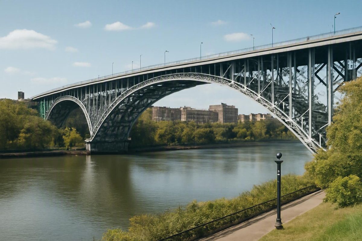
Structurally, the Alexander Hamilton Bridge is commonly described as an open-spandrel steel deck-arch bridge.
The steel arch can be seen from nearby public space, but the bridge’s primary identity is functional. It is interstate highway infrastructure built to move motor vehicles through a regional road network. The existence of pedestrian promenades on other New York bridges does not establish similar access here.
How the Bridge Fits Into New York’s Highway Network
The easiest way to understand the Alexander Hamilton Bridge is to follow I-95 from west to east.
Traffic arriving from New Jersey crosses the George Washington Bridge into upper Manhattan. I-95 then follows the Trans-Manhattan Expressway through Washington Heights. At the eastern side of Manhattan, the route crosses the Harlem River on the Alexander Hamilton Bridge and continues into the Bronx on the Cross Bronx Expressway.
That description sounds linear, but the physical setting is more complicated. The central steel arch is only one component of a larger transportation system containing elevated approaches, connecting ramps, interchange bridges and roadways at different levels. The infrastructure also fits around local streets, parkland, rail lines, Harlem River Drive and the Major Deegan Expressway.
Reconstruction records describe the wider bridge project as including the main span, associated ramps and interchange sections involving I-95 and I-87. In this context, I-87 is the Major Deegan Expressway along the Bronx side of the corridor. The rehabilitation contractor treated the arch bridge, connecting ramps, piers, foundations, drainage and signs as parts of one interconnected construction problem. Review the contractor’s project description.
This distinction matters when interpreting maps and statistics. A driver may say that they crossed the Alexander Hamilton Bridge while also using several approach structures and ramps in the surrounding interchange. An engineering contract can consequently cover much more infrastructure than the river arch alone.
The same issue affects traffic estimates. A bridge-only count should represent vehicles passing a defined counting point on the principal crossing. An interchange estimate may include traffic on ramps, approaches or other connected roadways. If two project pages use different geographic boundaries or counting methods, their daily totals can differ substantially without measuring the same thing.
The surrounding ramp system was historically known as the Highbridge Interchange. A later design source calls it the Alexander Hamilton Bridge Interchange and notes its former name. The newer terminology presents the bridge and interchange as one transportation complex, although the main arch remains a distinct structure.
For orientation, the west-to-east route is:
- George Washington Bridge area
- Trans-Manhattan Expressway through Washington Heights
- Alexander Hamilton Bridge over the Harlem River
- Cross Bronx Expressway in the Bronx
- Connections to other regional roads, including I-87 through the interchange system
This sequence is not live lane guidance. Ramp assignments, restrictions, construction conditions and closures can change. Consult a current official transportation service before driving.
Design and Dimensions: Why Published Numbers Differ
The Alexander Hamilton Bridge’s general structural form is clear even when its published measurements are not. Because the roadway sits above the arch, the bridge is a deck arch rather than a through arch.
The more difficult question is what a source means when it states the bridge’s “length.”
A participating engineering firm describes a 1,485-foot bridge containing a 505-foot steel-arch main span. Its measurement includes two Manhattan-side spans above parkland and Harlem River Drive and seven Bronx-side spans above I-87, rail infrastructure and local streets. That breakdown helps identify what the firm counted. See M&J Engineering’s dimensional and project overview.
Other sources publish a 1,525-foot bridge structure or a 2,375-foot total including approaches. The arch itself is variously reported at approximately 505, 550 or 555 feet. The responsible summary is therefore a documented range rather than one supposedly definitive measurement.
| Published figure | What it appears to measure | Why comparison requires care |
|---|---|---|
| 505 feet | Steel-arch main span in the government announcement and engineering portfolio | May reflect a particular structural definition of the arch |
| 550 feet | Rounded steel-arch measurement in the contractor’s description | Appears to be a rounded project figure |
| 555 feet | Longest span in the general bridge reference | May use different endpoints or terminology |
| 1,485 feet | Main bridge plus identified side spans | Appears to exclude some approaches counted elsewhere |
| 1,525 feet | Bridge structure in the 2014 government announcement | Its precise endpoints are not explained |
| 2,375 feet | Total length explicitly including approaches | Cannot be compared directly with bridge-structure-only figures |
These figures do not necessarily provide competing answers to one perfectly defined question. They can describe different physical boundaries.
An arch span generally concerns the principal distance crossed by the arch. The main bridge structure can include that arch and adjacent structural spans. Approach spans carry the roadway toward the central crossing. A large construction contract may include all of these, together with structures that are operationally connected but not part of the river arch.
The 1,485-foot and 1,525-foot figures appear to concern relatively limited definitions of the bridge structure. The 2,375-foot figure expressly includes approaches. Listing all three without explaining their scope would create false disagreement.
The main-span discrepancy should not be forced into artificial consensus either. A rounded 550-foot contractor figure falls between the published 505- and 555-foot measurements, but that does not make 550 feet the definitive answer. The sources may use different endpoints, structural conventions or terminology.
There is also a source-independence issue. Repetition across several participating companies does not necessarily represent several independent measurements.
For general research, the most transparent formulations are:
- Main arch span: approximately 505 to 555 feet, depending on the source and definition.
- Principal bridge length: approximately 1,485 to 1,525 feet in project-related accounts.
- Length including approaches: approximately 2,375 feet in the broader bridge reference.
An exact width or navigational clearance is best avoided because the supplied values are incomplete, inconsistent or ambiguously defined. Anyone who needs dimensions for engineering, navigation, permitting or legal purposes should obtain the applicable measurement from the responsible authority.
From the 1963 Opening to a Major Interstate Link
The Alexander Hamilton Bridge opened on January 15, 1963, the same day the Cross Bronx Expressway was completed. A historical bridge page places it on the I-95 route between the George Washington Bridge area and the Cross Bronx Expressway, although that page is a personal reference rather than an official transportation record. View the historical bridge overview.
A concise timeline is:
- January 15, 1963: The Alexander Hamilton Bridge opens to traffic.
- The same day: Completion of the Cross Bronx Expressway establishes the crossing’s immediate expressway context.
- From 1963: The bridge operates as the I-95 connection between the Trans-Manhattan Expressway and Cross Bronx Expressway.
- 2009: A major rehabilitation program begins.
- July 2014: The principal rehabilitation is officially reported complete.
- Later period: A separate completed project modernizes additional interchange ramps and more than a mile of roadway approaches; the supplied source does not give its completion date.
The shared opening date matters because the bridge did not begin as a local river crossing later adapted for interstate use. It entered service within the expressway connection between Manhattan and the Bronx.
Its location established its regional transportation role. The George Washington Bridge and interstate route into New Jersey lie to the west. The Cross Bronx Expressway and connections deeper into the metropolitan highway network lie to the east. The Alexander Hamilton Bridge closes the Harlem River gap between those road systems.
That documented configuration is enough to explain the bridge’s importance without speculating about economic effects or neighborhood development. It is an eight-lane I-95 crossing positioned between two major expressway segments.
The bridge is named for Alexander Hamilton. The supplied evidence does not establish the naming date, formal dedication process or reason for selecting Hamilton. It also does not provide sufficiently authoritative information to identify the original designer or builder.
The bridge should not be confused with two nearby crossings:
- The Washington Bridge is a separate structure.
- The High Bridge is another distinct crossing with a different history and transportation role.
- The Alexander Hamilton Bridge is the I-95 highway crossing discussed here.
Their proximity can make photographs and location descriptions confusing, especially where elevated ramps and approach structures overlap within the Harlem River valley.
What the 2009–2014 Rehabilitation Changed
The major rehabilitation began in 2009, and July 2014 is the clearest officially reported completion point for the principal program. Some participating-company pages display 2013 or 2015, but those years may refer to a supplier’s portion of the work, a portfolio convention or another administrative milestone.
The project extended far beyond resurfacing the roadway over the arch. It covered the main bridge, interchange structures, ramps, replacement bridges, roadway approaches, utilities and nearby park work.
Major categories of work included:
- Bridge-deck replacement or rehabilitation
- New pavement
- Widening for standard shoulders
- Structural-steel strengthening and modification
- Work on piers and foundations
- Seismic retrofits
- New bearings
- Replacement pavement joints
- Drainage improvements
- Highway lighting
- Overhead signs and sign structures
- Barriers
- Utility work
- Intelligent transportation system elements
- Rehabilitation or replacement of connected ramps
The main bridge deck was widened by 11 feet on each side to introduce standard shoulders. That required more than adding pavement at the edges: the existing piers and superstructure framing also had to be modified or strengthened.
The wider contract replaced the eastbound Trans-Manhattan Expressway ramp to the Washington Bridge and the Undercliff Avenue Bridge. It also rehabilitated six Highbridge Interchange ramp bridges. M&J Engineering describes a nine-bridge contract, six construction stages on the main bridge and four temporary ramps assembled from eight temporary bridge structures to maintain traffic. The firm reports a construction cost of $420 million and states that the project was completed in July 2014. Examine the engineering firm’s rehabilitation account.
The government announcement put the rehabilitation value at approximately $415 million. Other supplied pages publish values from $407 million to $420 million: the general bridge reference gives $407 million, the contractor lists $419 million and the inspection consultant lists $420 million. These may represent different contract values, reporting dates or definitions of total project cost. The evidence does not resolve the accounting differences well enough to declare one figure universally correct.
The broader program also reportedly contained $20 million in Highbridge Park enhancements, including playground work and a new 25,000-square-foot skateboard park. Because park improvements, replacement bridges and interchange ramps were included, the headline cost should not be interpreted as the price of rehabilitating the central arch alone.
Project participants and public officials characterized the work as improving safety, mobility, durability and schedule performance. Those are attributed assessments rather than independently demonstrated guarantees. The physical scope of the completed work is more firmly supported than claims about its long-term outcomes.
How Crews Rebuilt the Crossing While Traffic Continued
Rehabilitating a large urban bridge is difficult even when it can be closed. The Alexander Hamilton Bridge project added a more demanding constraint: the crossing and its connected roads had to continue carrying traffic during much of the work.
Construction on the main bridge was divided into six stages.
Four temporary ramps made from eight temporary bridge structures were central to this process. They provided substitute paths around permanent ramp sections under rehabilitation.
Pier work addresses the supports beneath the deck and approaches.
The rehabilitation also involved pier caps, steel framing, foundations and seismic components. Construction supplier Doka describes deck replacement, strengthening of the steel arch and support beams, and replacement or restoration of eight pier caps. Some other measurements on its page concern proprietary formwork systems and should not be treated as general bridge dimensions. Read Doka’s construction case study.
That does not establish immunity from earthquake damage; it shows that seismic behavior was explicitly addressed during rehabilitation.
The contractor says its shoring method reduced the amount of temporary support infrastructure required around an existing pier. It also claims that construction Stages 4 and 5 finished more than 35 days ahead of schedule. Because the project page does not provide independent schedule records, that performance statement should remain attributed to the contractor. Review the contractor’s temporary-works account.
The reconstruction illustrates several recurring constraints in urban infrastructure work:
- Limited space: The bridge and ramps occupy a narrow river and transportation corridor.
- Interconnected roads: Closing one ramp can redirect traffic onto several other facilities.
- Continuous demand: The crossing remained part of a heavily used interstate route.
- Nearby infrastructure: Work occurred around rail lines, Harlem River Drive, I-87 and local streets.
- Communities and parks: Construction had to account for access beyond the highway.
- Structural sequencing: Removing one component could affect the support or usability of another.
Temporary ramps and staged construction reduced the need for a full long-term closure. They do not prove that the work caused no disruption. Detours, shifting traffic patterns, construction activity and local access constraints can affect surrounding areas even when an interstate remains open.
The project’s central logistical accomplishment was renewing major parts of the bridge-and-ramp system while preserving a functioning transportation route. The supplied evidence is less suited to measuring the full experience of nearby residents or determining whether every disruption was minimized.
Traffic Estimates and Later Interchange Work
The supplied evidence does not establish one reliable current daily traffic figure. Published totals refer to different years, geographic areas and potentially different counting methods.
Bridge-focused historical figures generally fall between approximately 178,000 and 190,000 vehicles per day:
- The general bridge reference reports approximately 182,000 vehicles per day in 2011 and about 178,000 in 2016.
- Construction supplier Doka uses an undated estimate of approximately 188,000 vehicles per day.
- The 2014 government announcement says the work accommodated approximately 190,000 vehicles daily.
Doka does not explain the date or counting method behind its figure, so its estimate is best treated as broad historical project information rather than a current official count. See the supplier’s bridge and traffic summary.
Higher totals appear in descriptions of the wider crossing or interchange. The rehabilitation contractor estimated approximately 300,000 vehicles per day in the project area. A later design firm reports more than 250,000 motorists daily at the crossing. Those figures may include ramp, approach or interchange traffic not represented in a bridge-only count.
It would therefore be misleading to state that the bridge currently carries exactly 300,000 vehicles every day. The evidence neither establishes that as a present bridge-only total nor supplies a consistent methodology for comparing it with the lower figures.
The defensible conclusion is narrower: dated bridge-focused estimates are generally around 178,000 to 190,000 vehicles daily, while broader project or interchange descriptions exceed 250,000. None should be used as a live congestion forecast.
Later ramp modernization
Work on the surrounding road system did not end with the principal 2009–2014 rehabilitation. A later project modernized three interchange ramps and more than one mile of roadway approaches. Its project page lists the work as complete but does not provide a completion date or fully explain its contractual relationship to the earlier program.
The later design used full-length fascia girders. Extending these girders along the full ramp provided a continuous structural solution while allowing each ramp to be widened by two feet on each side.
The design also used seismic isolation bearings, components intended to help manage movement between the elevated ramp structure and its supports. The stated objective was to retain the existing piers within a restricted footprint rather than requiring a much larger reconstruction area.
Lead designer STV characterizes the solution as innovative and says it reduced closures while improving redundancy, safety and resilience. Those are the firm’s descriptions of its own work, not independent findings. More directly supported are the project’s physical elements: three ramps, more than a mile of approaches, full-length fascia girders, two-foot widening on each side and seismic isolation bearings. Read STV’s interchange project description.
STV also calls the facility the Alexander Hamilton Bridge Interchange, formerly the Highbridge Interchange. The terminology reinforces a central point: the main arch cannot be fully understood without its approaches and connecting ramps.
Historical traffic counts and completed-project pages do not establish current travel times, lane availability or maintenance conditions. Drivers should check a current official transportation service before entering the corridor.
Where to View the Bridge Without Treating It as a Walking Route
Visitors who want to see the Alexander Hamilton Bridge from public space have a documented option on the Bronx waterfront: Bridge Park.
NYC Parks identifies Bridge Park as a 7.16-acre neighborhood park along the Harlem River between West 175th Street and the Alexander Hamilton Bridge. The agency says the park offers views of the Alexander Hamilton Bridge, Washington Bridge, Highbridge Park and High Bridge. It also identifies walking or cycling along the greenway and spending time near the shoreline as activities within the park. Check the official NYC Parks page for Bridge Park.
This distinction is important: Bridge Park is a public viewpoint near and below the highway bridge. Its greenway does not establish an entrance onto the Alexander Hamilton Bridge.
Several structures are visible in the immediate area:
- Alexander Hamilton Bridge: The eight-lane I-95 deck-arch crossing.
- Washington Bridge: A separate nearby bridge.
- High Bridge: Another distinct crossing in the broader corridor.
- Approach and ramp structures: Elevated highway elements that can obscure or visually blend with the main arch.
The NYC Parks page establishes the shoreline and greenway setting, but it does not guarantee a particular photography position, unobstructed sightline or current path condition. Seasonal vegetation, maintenance and construction can change the experience.
The supplied page also does not establish current park hours, exact entrances, available facilities, accessibility conditions or personal safety conditions. Confirm present park and greenway information directly with NYC Parks before visiting. Historical photographs or observations from 2005 should not be used to characterize present-day conditions.
The supplied evidence does not establish whether pedestrians or cyclists are legally permitted to cross the Alexander Hamilton Bridge. Nearby greenway information concerns public space along the Harlem River, not access to the interstate structure. Anyone planning a nonmotorized route should verify current rules and legal crossings with the responsible transportation and parks authorities.
The Bridge in Practical Terms
The Alexander Hamilton Bridge is best understood as an eight-lane I-95 highway crossing that has connected Manhattan and the Bronx since 1963. A third-party bridge reference reports that the crossing has no toll, but travelers should distinguish that attributed detail from charges they may encounter elsewhere on a longer regional journey.
Its steel arch is the most recognizable part of the bridge, yet the crossing operates within a complicated interchange linking the Trans-Manhattan and Cross Bronx expressways, the George Washington Bridge area and connections around I-87.
The 2009–2014 rehabilitation renewed the main bridge and substantial surrounding infrastructure while traffic continued through staged work zones and temporary ramps. Published dimensions, costs and traffic totals remain source-dependent because different accounts measure different structures, project limits or roadway systems.
Bridge Park is the documented public viewpoint. For current road conditions, closures, access rules, park information and greenway conditions, consult the responsible official transportation and parks services before traveling.
Frequently Asked Questions
Is there a toll on the Alexander Hamilton Bridge?
The supplied third-party bridge reference lists the Alexander Hamilton Bridge as toll-free. That does not mean every bridge, tunnel or toll road on a longer regional trip is free. See the attributed bridge and toll listing.
How long is the Alexander Hamilton Bridge?
It depends on what is being measured. Project-related accounts give principal bridge lengths of approximately 1,485 or 1,525 feet, while a broader reference gives 2,375 feet including approaches. Published measurements for the main steel-arch span range from approximately 505 to 555 feet.
For a general description, “roughly 1,500 feet for the principal bridge” is reasonable as long as it is not confused with the broader approach-inclusive measurement.
How many vehicles use the bridge each day?
There is no consistent current bridge-only figure in the supplied evidence. Historical bridge-focused estimates are lower than the totals published for the wider interchange, where ramps and approaches may also be counted. STV’s later project page, for example, reports more than 250,000 daily motorists for the broader crossing without explaining its counting methodology. Review the later interchange description.
These historical estimates should not be used to predict current congestion or travel times.
Can pedestrians or cyclists cross the Alexander Hamilton Bridge?
The supplied evidence does not establish legal pedestrian or bicycle access across the Alexander Hamilton Bridge. It establishes only that nearby Bridge Park contains shoreline and greenway space; it does not show that the park provides access onto the interstate crossing.
Verify any proposed nonmotorized route with the responsible transportation and parks authorities rather than assuming that a nearby greenway continues across the bridge.
Where can visitors get a public view of the bridge?
Bridge Park on the Bronx side of the Harlem River is the documented public viewpoint. NYC Parks identifies it as a place to see the Alexander Hamilton Bridge, Washington Bridge, Highbridge Park and High Bridge. Consult the current Bridge Park page before visiting.
Confirm current hours, entrances, accessibility, facilities and greenway conditions directly with NYC Parks.