 New York Know
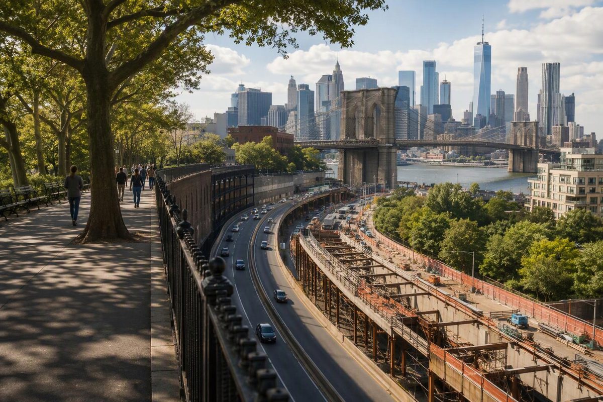
The Brooklyn Heights Promenade is a short, elevated walkway with broad views of Lower Manhattan, New York Harbor and the Brooklyn Bridge. It is not a full-day attraction. Allow 30 to 45 minutes for the promenade itself, or two to three hours when you add Brooklyn Heights and the DUMBO waterfront.
For a first visit, approach through Brooklyn Heights, walk the promenade from south to north, then descend to Brooklyn Bridge Park. This sequence moves from brownstone streets to skyline views and finally the waterfront without much retracing.
What to expect
The promenade runs along the western edge of Brooklyn Heights, officially from Joralemon Street to Orange Street between the BQE and Columbia Heights or Montague Terrace, according to NYC Parks. The overlook is roughly one-third of a mile long.
A direct walk takes about 10 minutes, but the benches and changing sightlines reward a slower pace. Governors Island and the harbor lie to the south, Lower Manhattan is across the East River, and the Brooklyn Bridge appears toward the north.
There is no ticket or admission gate. This is an everyday public walkway rather than an observation deck, and the highway runs below it. Expect traffic noise as part of the setting.
A compact two-hour route
1. Start at Borough Hall and cross Brooklyn Heights
Borough Hall is the easiest starting area if you want to see the neighborhood before the overlook. Several subway lines stop nearby, and this approach avoids treating the promenade as an isolated photo stop.
Walk west on Montague Street, a commercial stretch with places to buy coffee or food. Continue until Montague meets the promenade. Before turning north, you can make a short detour south to Remsen Street for another residential block and harbor-facing outlook.
2. Walk north along the promenade
Turn north and follow the railing toward the Brooklyn Bridge. Navigation is simple: remain on the overlook and pause where the view opens between trees. Benches make it easy to slow down, although the walkway can feel busy around sunset and on mild weekends.
The landscape has an unusual origin. Plans to drive the Brooklyn-Queens Expressway through Brooklyn Heights met local opposition; the eventual design placed the highway along the neighborhood’s western edge with the cantilevered promenade above it. The promenade was dedicated in 1950, according to the NYC Parks history.
Brooklyn Heights later became New York City’s first designated historic district. Its streets retain a substantial mix of Federal, Greek Revival, Gothic Revival and Italianate architecture, as outlined by The Cultural Landscape Foundation.
3. Descend to Brooklyn Bridge Park and DUMBO
Leave the promenade at its Orange Street end and continue toward Squibb Park. Squibb Park Bridge provides a sloping connection down to Brooklyn Bridge Park. Walk bicycles and scooters across it: Brooklyn Bridge Park permits cycling only on its designated greenway and requires riders to dismount on Squibb Bridge and other park paths, according to the park’s directions and visitor rules.
At waterfront level, turn north for Pier 1, Fulton Ferry Landing and DUMBO. Pier 1 provides a lower perspective on the Brooklyn Bridge and Manhattan skyline, complementing the elevated promenade view. Continue with this DUMBO walking route if you have another 60 to 90 minutes.
For a shorter finish, use High Street or York Street for the subway. For a longer one, cross the Brooklyn Bridge into Lower Manhattan—but treat that as another substantial walk, not a quick add-on.
Which direction should you walk?
South to north is best for a first visit. You can stop for food around Montague Street first, keep the Brooklyn Bridge ahead during much of the walk and finish near the most direct descent to Brooklyn Bridge Park and DUMBO.
North to south works better when starting in DUMBO. Climb via Squibb Park Bridge, enter the promenade near Orange Street and finish around Montague Street, with food options and several subway stations around Borough Hall and Court Street.
If your day already includes the Brooklyn Bridge, DUMBO and the waterfront, walking north to south may prevent backtracking. The promenade fits naturally into this compact cluster; there is little reason to leave for Midtown between stops. See the broader Brooklyn area plans for half-day and full-day combinations.
Getting there
Useful subway approaches include:
- 2 or 3 to Clark Street: close to the northern half of the promenade.
- A or C to High Street: useful for DUMBO, Squibb Park and a north-to-south walk.
- 2, 3, 4, 5 or R at Borough Hall or Court Street: best for the south-to-north neighborhood route.
- F to York Street: practical for DUMBO, though farther from the promenade and followed by sloping streets.
Service changes and elevator outages can alter the best choice, so check the MTA before leaving. Driving is a poor default: Brooklyn Bridge Park says nearby parking is very limited and recommends public transportation, walking or biking.
Brooklyn Bridge Park—the waterfront park below the promenade—is free and posts daily hours of 6 a.m. to 1 a.m. on its official visitor page.
Accessibility and practical details
The promenade’s main path is paved and largely level, but its approaches require more attention. Brooklyn Heights sits above the waterfront, so travel between the promenade and DUMBO involves a grade. Squibb Park Bridge provides a direct route without stairs; nearby staircases and steeper streets may be less suitable.
Brooklyn Bridge Park describes the waterfront park as ADA accessible and lists Access-A-Ride addresses for Pier 1 and its southern entrance on the same directions page. That does not mean every route down from Brooklyn Heights is equally convenient, so check your chosen subway station’s elevator status and approach separately.
There is no visitor center on the promenade. Use Montague Street for cafés and shops, and plan restroom stops in Brooklyn Bridge Park rather than assuming facilities will be available on the overlook. An extra layer can be useful outside summer because the waterfront is exposed to wind.
Morning generally suits a quieter walk. Late afternoon offers changing light, while dusk brings the illuminated skyline; sunset can also draw more people. After dark, choose the exit that leads most directly to your onward train rather than improvising a route downhill.
Check the BQE project before a future visit
The promenade sits above the BQE’s “Triple Cantilever,” tying its future directly to the highway’s long-term rehabilitation. As of September 2026, NYC DOT says the proposal is preparing to enter environmental review. The agency currently expects construction to begin in 2029 and finish by 2040, including installation and removal of temporary bypass structures.
NYC DOT says the proposal is intended to rehabilitate and protect the promenade, but environmental review is still underway and construction effects are not final. Check the NYC DOT BQE Central project page when planning a later trip.
The promenade works best as the geographic hinge in a larger walking day: historic Brooklyn Heights above, Brooklyn Bridge Park below and DUMBO immediately beyond.