 New York Know
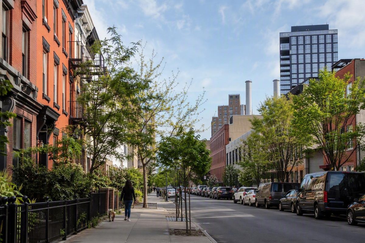
East Williamsburg at a Glance
East Williamsburg, Brooklyn, NY, is best understood as a loosely defined part of northwest Brooklyn between Williamsburg and Bushwick.
For visitors, that uncertainty matters less than the shape of the streets. Residential side streets meet commercial corridors, while active industrial property and adapted warehouse buildings become more prominent toward the eastern side.
The result is a neighborhood of contrasts:
- older walk-ups and newer condominium buildings;
- grocery stores, cafés, restaurants, bars, and independent shops;
- residential blocks alongside commercial and industrial property;
- active warehouses as well as former industrial buildings converted to lofts, studios, or creative uses;
- Cooper Park as a natural outdoor pause;
- arts, music, nightlife, and everyday neighborhood activity.
A commercial neighborhood profile similarly emphasizes the coexistence of residential and industrial spaces, adaptive reuse, dining, nightlife, arts, music, and Cooper Park. Its promotional language should not be treated as an objective ranking, but the basic description of mixed land use is consistent with the other supplied coverage.A commercial profile describes East Williamsburg’s mixed uses and adaptive reuse
East Williamsburg makes the most sense as a half-day neighborhood walk. A longer visit can work if you have a directly confirmed restaurant reservation, performance, or evening event, but the available evidence does not support a current all-day itinerary built around named venues.
This guide therefore offers a cautious orientation rather than a tested turn-by-turn route, definitive boundary map, live venue directory, safety guarantee, or relocation assessment. It follows a practical, walking-focused editorial approach: choose a compact area, move in a generally consistent direction, and leave enough flexibility to respond to current conditions.
Before visiting, check the details that could affect your day, including subway service, station accessibility, weather, venue status, reservations, ticket rules, and the journey home.
Where Is East Williamsburg? Understanding the Disputed Boundaries
The available evidence does not establish one official or universally accepted boundary for East Williamsburg. One neighborhood guide explicitly says that both the boundaries and the area’s status as a distinct neighborhood are debated. It associates East Williamsburg with the Grand Street, Montrose Avenue, and Morgan Avenue stops on the L train, making those stations useful orientation points without turning them into official borders.Corcoran describes the boundary debate and associates the area with three L stations
Relational descriptions are more useful than a rigid outline. East Williamsburg is commonly discussed as being:
- east of the better-known core of Williamsburg;
- west or northwest of Bushwick, depending on the definition;
- near Greenpoint to the north;
- and oriented toward Newtown Creek and the direction of Maspeth at its industrial edge.
These descriptions still leave room for disagreement.
Use stations as anchors, not borders
- Morgan Avenue for the warehouse and industrial-edge character toward Newtown Creek.
These are editorial route choices, not official neighborhood divisions. They do not establish that every surrounding block is universally recognized as East Williamsburg.
Morgan Avenue is particularly useful for understanding land use. The cited neighborhood guide presents it as a functional transition, with commercial and residential uses more evident to the west and industrial uses becoming more prominent to the east toward Newtown Creek and the East Williamsburg Industrial Park. That description should be read as a broad organizing idea rather than a claim that the streets change instantly at one intersection.
What a useful visitor map should show
Any map accompanying a visit should label the neighborhood outline as approximate. More important than the border itself are the landmarks and corridors that make the area legible:
- Grand Street L station;
- Montrose Avenue L station;
- Morgan Avenue L station;
- Grand Street;
- Graham Avenue;
- Metropolitan Avenue;
- Cooper Park;
- Morgan Avenue;
- Newtown Creek.
A map built around those anchors will be more useful than one implying that East Williamsburg begins or ends cleanly at a particular street.
How East Williamsburg Compares with Williamsburg and Bushwick
East Williamsburg should not be treated as interchangeable with Williamsburg proper or Bushwick. At the same time, the three areas should not be presented as territories separated by unquestionable borders.
East Williamsburg works most clearly as a transition area. Its streets overlap with the naming conventions, cultural associations, and built environments of its better-known neighbors. The differences are therefore best explained through the experience of a walk rather than through broad claims about which neighborhood is livelier, safer, cheaper, or better.
A walk may move from a commercial corridor to a quieter residential street, then toward Cooper Park, warehouse buildings, nightlife uses, or industrial property. The interest lies in those transitions rather than in a dense circuit of famous attractions.
Active industry is an important part of that identity. Describing the area only through restaurants, converted lofts, and nightlife would overlook the warehouses and industrial property that remain. Describing it only as an industrial district would be equally incomplete because the western and central portions also contain homes, local commerce, food businesses, bars, and public space.
Williamsburg and Bushwick also have housing, nightlife, creative businesses, and converted industrial buildings. None of those features belongs exclusively to East Williamsburg. The practical distinction is the route experience: within a relatively compact area, visitors can encounter residential streets, neighborhood commerce, adaptive reuse, and an increasingly industrial landscape.
A useful decision rule is:
Choose East Williamsburg for a walking-focused outing combining local commercial streets, Cooper Park, food or drink, and industrial contrast—not for a checklist of famous sights.
It can suit a repeat visitor to New York, someone interested in everyday urban form, or a traveler attending an evening event nearby. Visitors seeking concentrated landmark sightseeing may prefer to spend their limited time elsewhere.
Getting There and Choosing the Right L Train Stop
The L train is the clearest transit reference supported by the supplied neighborhood coverage. Grand Street, Montrose Avenue, and Morgan Avenue provide three possible starting points, each suited to a different version of the visit.
Start at Grand Street for a compact first route
Use the Grand Street L station when you want to focus on Grand Street, Graham Avenue, nearby residential blocks, and Cooper Park.
This is the most straightforward editorial starting point for the shorter route described below.
Start at Montrose Avenue for the mixed middle
This option is most useful when observing changes in land use is a larger priority than following the complete route from its western end.
Start at Morgan Avenue for a targeted eastern visit
Use Morgan Avenue when your main interest is the warehouse and industrial-edge character toward Newtown Creek, or when you have a confirmed destination nearby.
Morgan Avenue is better treated as a targeted arrival point or as the end of an eastbound walk than as a default starting point for every visitor. The supplied evidence does not establish a continuous visitor corridor around the station, so confirm the location and route for any essential stop in advance.
One brokerage profile also claims access to the J/Z lines. That claim is too imprecise for primary directions because its usefulness depends on the assumed neighborhood boundary, the intended station, and the distance a visitor is prepared to walk. The L is the more consistent reference across the available sources.
Immediately before traveling, verify:
- current L train service;
- weekend or late-night changes;
- station accessibility for the specific stop you intend to use;
- the entrance or exit that suits your first direction;
- and service from the station nearest your planned finish.
Published neighborhood profiles cannot establish live subway conditions, and the supplied evidence does not confirm current accessibility at any of the three stations.
A Walking-First Route Through East Williamsburg
The most coherent first route begins near the Grand Street L station, uses Grand Street and Graham Avenue to introduce the commercial and residential character, includes Cooper Park, and continues toward Metropolitan Avenue, Montrose Avenue, or Morgan Avenue only when time and interest justify the extension.
This is a planning framework, not a field-tested sequence of turns. The available evidence does not support precise walking times, route distances, or current street-by-street conditions.
Stage 1: Begin around Grand Street
After leaving the Grand Street station, use Grand Street to establish the rhythm of the area. Notice the relationship between storefronts, service businesses, residential buildings, and the side streets leading away from the corridor.
There is no need to identify the “real” neighborhood boundary while walking. Instead, concentrate on visible changes in building form and land use. The uncertainty around the name is part of the context, but it need not control the outing.
If you want coffee, food, or shopping at the beginning of the route, select one business only after confirming its current address, operating status, hours, and suitability for your needs. The evidence pack does not verify any individual venue for current publication.
Stage 2: Explore Graham Avenue and its side streets
Graham Avenue gives the route a north-south dimension. A resident-authored guide describes it as the principal thoroughfare south of Grand Street, identifies its honorary name as Avenue of Puerto Rico, and recommends Metropolitan Avenue, Graham Avenue, and Grand Street as the main corridors for exploring the area.A resident-authored walking guide identifies the principal corridors and Avenue of Puerto Rico
Use both the avenue and selected side streets. The guide reports a mix of older walk-ups, newer condominiums, grocery stores, bodegas, bars, longtime residents, newer arrivals, and families. This is one resident’s account rather than a current demographic survey, but it provides a useful framework for noticing the neighborhood’s built form and commercial life.
Remember that residential buildings and ordinary businesses are not attractions staged for visitors. Keep entrances clear and ask permission before photographing identifiable people.
Stage 3: Pause at Cooper Park
Make Cooper Park the route’s outdoor pause. It breaks up the commercial and residential walking and creates a natural decision point before any eastward extension.
The supplied sources support Cooper Park as a local green-space stop, but they do not establish a current inventory of facilities, restrooms, programming, accessible entrances, or construction conditions. If a particular amenity is essential, consult current park information before relying on it.
At this point, a compact visit may already feel complete: Grand Street, Graham Avenue, a few side streets, one verified food or retail stop, and the park.
Stage 4: Use Metropolitan Avenue as a connector
Metropolitan Avenue is the third supported walking anchor. Use it to connect parts of the route rather than adding unnecessary backtracking.
Your exact direction should depend on the day’s plan. Because the route has not been field-verified for current conditions, follow live walking directions and adjust for construction or other disruptions.
Stage 5: Extend toward Montrose and Morgan when the contrast matters
Continue toward Montrose Avenue if you want to see more of the area’s mixed residential and industrial character. Extend to Morgan Avenue when industrial land use is a specific interest or when a confirmed destination gives the walk a clear endpoint.
The purpose of this extension is not to find another concentration of conventional attractions. It is to observe the broad shift toward warehouse and industrial property described in the available neighborhood coverage.
Do not continue east simply to make the route longer. Establish the final destination and return station in advance, particularly if the extension will take place after dark or around an event.
Short and long versions
Short framework: Begin near Grand Street station, explore Grand Street and Graham Avenue, use selected residential side streets, pause at Cooper Park, and finish at a practical L station.
Choose this version for a half-day, uncertain weather, limited walking energy, or a first visit without evening plans.
Long framework: Follow the shorter route, add Metropolitan Avenue, continue through the Montrose Avenue area, and finish near Morgan Avenue.
Choose this version only when the land-use transition is a central interest or when a directly confirmed meal, performance, or event provides a useful endpoint. Without verified stops and timings, it should be treated as an optional extension rather than a fully validated all-day itinerary.
What to Notice: Culture, Commerce, and Industrial Change
East Williamsburg’s identity extends beyond cafés and nightlife. The available sources describe cultural continuity, residential change, local commerce, industrial activity, and adaptive reuse occurring within the same loosely defined area.
A resident-authored guide identifies Italian heritage and Latin cultural celebrations as parts of local cultural life. It also highlights Graham Avenue’s honorary designation, Avenue of Puerto Rico. That name provides meaningful cultural context, but it should not be used to infer current demographic proportions, political representation, or who belongs in the neighborhood.
Look for the institutions that support everyday life: grocery stores, bodegas, food businesses, household shops, apartment entrances, places of worship, and informal gathering points. Nightlife may be especially noticeable to an evening visitor, but it represents only one part of the area.
Building forms provide another useful lens. The resident guide reports older walk-ups alongside newer condominiums, while real-estate profiles describe active warehouses and former industrial buildings converted to lofts or creative uses. The defensible story is one of coexistence and uneven change—not the total disappearance of industry and not the complete transformation of the area into a leisure district.
Redevelopment should not be romanticized. The supplied sources do not establish its effects on affordability, displacement, longtime communities, industrial employment, noise, or the survival of local businesses. A converted warehouse may be visually prominent, but its appearance alone says little about who benefited from the change.
One commercially published guide connects the area to the Dutch settlement of Boswijck and the later Town of Bushwick, which it says included the Village of Williamsburg for a period. It also links several street names to early Dutch landowners. These are useful historical leads, but the source provides no archival citations, so the account should not be treated as settled history without further corroboration.Corcoran provides the source-attributed historical account
For a first visit, visible land-use transitions are the strongest focus. Notice where residences sit above businesses, where older buildings meet newer construction, and where commercial and residential uses give way to larger industrial properties. East Williamsburg becomes more intelligible through those changes even when its perimeter remains uncertain.
Food, Drinks, Shopping, Music, and Cooper Park
The supplied sources describe a range of cafés, restaurants, food shops, bars, breweries, independent retailers, creative spaces, and music venues. However, they do not establish which individual businesses are operating now, whether their hours remain accurate, or whether they are suitable for a particular itinerary.
For that reason, plan by category rather than relying on an unverified “best of” list.
Coffee and cafés
A café can work as an opening anchor near Grand Street, Graham Avenue, or Metropolitan Avenue. Choose one through a current official business channel and confirm:
- operating status;
- address;
- opening hours;
- seating or takeaway arrangements;
- accessibility information;
- and proximity to the rest of your route.
If breakfast or a meeting depends on the stop, verify it shortly before leaving.
Restaurants and food shops
Restaurants, specialty food businesses, casual counters, and neighborhood groceries can fit naturally into the walk.
For lunch, choose a confirmed place near the middle of the compact route. For dinner, it may be more practical to select the restaurant first and work backward when choosing your starting station and direction.
Avoid planning around an older editorial mention alone. The supplied resident guide names numerous businesses, but it also warns that important details should be checked because information can change after publication.
Bars and breweries
Bars and breweries are part of the neighborhood mix described in the available coverage. An evening stop can extend a half-day walk, but it also makes return planning more important.
Before including one, verify:
- opening hours;
- identification or age requirements;
- reservations or event schedules;
- accessibility;
- the official address;
- and the practical route to the subway afterward.
A neighborhood label does not establish that a venue is equally convenient to all three L stations.
Independent retail
Independent shops can be useful walking anchors because they fit between other route segments. They are also vulnerable to outdated listings, changed hours, and relocation.
Confirm that a shop is still operating at the listed address and that its opening hours align with your visit. Do not build a route around a name found only in an older neighborhood guide.
Live music and creative venues
A concert or performance can provide a clear reason to remain in the area after dark. For any event, use the venue’s current official information to confirm:
- the event date;
- ticket requirements;
- age restrictions;
- door and performance times;
- bag rules;
- accessibility arrangements;
- and the return route.
The supplied evidence supports live music as part of the area’s visitor appeal but does not verify a particular current event or venue operation.
Cooper Park and time outdoors
Cooper Park is the clearest outdoor stop in the supplied neighborhood sources. Use it as a pause between route segments rather than assuming specific facilities or scheduled programming.
The park also prevents the day from becoming a sequence of purchases. Time spent sitting, looking at the surrounding building forms, and deciding whether to continue can be as useful as another commercial stop.
Build the day around a few confirmed anchors
A sensible visit needs only two or three current anchors:
- one café, food stop, or independent shop;
- Cooper Park;
- and, if desired, a dinner reservation or ticketed event near the finish.
For every essential business or venue, confirm its operating status, official address, current hours, accessibility, price expectations, booking requirements, and nearest practical station. Leave the rest of the schedule open enough for the walk itself.
Practical Planning for Daytime and Late-Night Visits
Street conditions can differ by block, hour, lighting, activity, weather, and access to transit. The supplied evidence does not support a neighborhood-wide safety verdict.
During the day, keep the route compact and know which L station you will use if you decide to stop early. If weather or mobility needs make a longer walk impractical, use the shorter Grand Street–Graham Avenue–Cooper Park framework rather than forcing the eastern extension.
For an evening visit, plan the journey home before entering a restaurant, bar, brewery, concert, or event. General visitor guidance recommends favoring active, well-lit routes, using direct late-night transit where practical, and choosing a cab or rideshare when walking conditions feel uncertain or transfers become unnecessarily complicated.A June 2026 visitor-safety guide emphasizes situational decisions and planned late-night returns
A cab or rideshare may be the more practical choice when:
- the intended walk to transit feels too quiet;
- service changes create complicated transfers;
- construction makes the route unclear;
- weather deteriorates;
- someone in the group has limited mobility;
- or uncertainty about the route is adding avoidable stress.
That advice does not mean East Williamsburg is uniformly dangerous. Nor does activity around one venue prove that every surrounding block will feel the same. Make decisions using the immediate conditions, current transit information, and the needs of your group.
For current conditions, consult official NYPD crime information and MTA service and safety guidance rather than using citywide statistics to judge an individual block. In an immediate emergency, call 911. For non-emergency New York City assistance, use 311.The visitor guide identifies 911 and 311 and points readers toward official city resources
Before leaving, confirm in one final check:
- subway service and station accessibility;
- weather and daylight;
- operating status for every essential stop;
- reservations, tickets, and event times;
- accessibility information for required venues;
- the route between evening destinations;
- and the journey home from the final stop.
Frequently Asked Questions
Is East Williamsburg an official neighborhood with fixed boundaries?
The supplied evidence does not establish one fixed, universally accepted boundary. The neighborhood’s outline—and, in some discussions, its distinct identity—is debated.
For visitor planning, use Grand Street, Montrose Avenue, Morgan Avenue, Graham Avenue, Metropolitan Avenue, Cooper Park, and Newtown Creek as orientation points. Treat any drawn border as approximate.
Which subway stops serve East Williamsburg?
The L stations most consistently associated with the area are Grand Street, Montrose Avenue, and Morgan Avenue.
Check live service and accessibility information before traveling.
What streets are best for a first walk through East Williamsburg?
Use Grand Street, Graham Avenue, and Metropolitan Avenue as the main framework.
A simple visit begins near Grand Street station, explores Grand Street and Graham Avenue, includes Cooper Park, and then uses Metropolitan Avenue as a connector. Continue toward Montrose or Morgan Avenue only when you want a longer land-use-focused walk or have a confirmed destination.
What is there to do in East Williamsburg besides eat and drink?
Visitors can explore independent retail, residential side streets, older and newer building forms, Cooper Park, live music or creative spaces, and the transition from commercial and residential blocks toward warehouse and industrial property.
The neighborhood walk is the central activity. Its appeal comes from changes in land use, architecture, and street function rather than from conventional monuments.
Is East Williamsburg safe to visit at night?
No responsible neighborhood-wide guarantee can be made. Conditions vary by route, time, lighting, activity, weather, and transit access.
Plan the return journey in advance, favor active and well-lit routes, and use direct transit where practical. Choose a cab or rideshare if the walk or transfer feels uncertain. Call 911 for an immediate emergency and use 311 for non-emergency city assistance.
East Williamsburg ultimately makes more sense as a walk through changing streets and land uses than as a precisely outlined attraction district. Begin near an L station, use Grand Street, Graham Avenue, and Metropolitan Avenue as your anchors, pause at Cooper Park, and extend toward Morgan Avenue only when the industrial contrast or a confirmed destination genuinely interests you. A rewarding visit depends less on resolving the boundary debate than on keeping the route compact and checking current venue, transit, accessibility, weather, and return details before setting out.