 New York Know
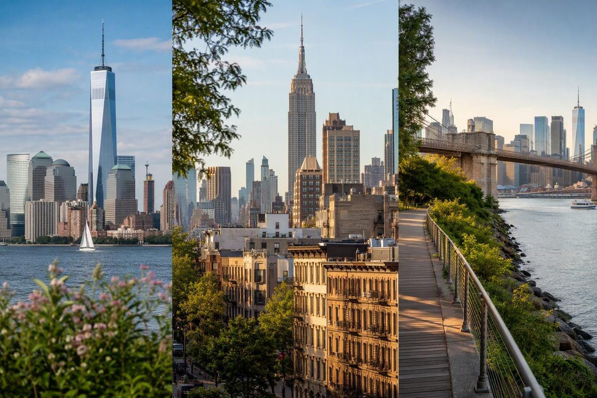
The New York skyline is not a single view. Lower Manhattan gathers around One World Trade Center, while Midtown is associated with the Empire State Building, the Chrysler Building, Hudson Yards, and the slender towers near 57th Street. Change your position, and the balance between those landmarks changes with it.
That distinction matters when planning a visit. The Brooklyn waterfront can provide a broad Lower Manhattan panorama, but it does not emphasize the East Side in the same way as Long Island City or Roosevelt Island. An observation deck adds height, while a ferry or tram turns the skyline into a moving sequence.
The efficient approach is to decide which part of the skyline matters most, then choose a viewpoint that fits the surrounding neighborhood. This guide focuses on that geographic strategy. Operating hours, fares, entrances, closures, accessibility arrangements, and photography rules can change, so verify those details with the relevant operator or park authority before departure.
Start by Deciding Which New York Skyline You Want to See
Here, “New York skyline” primarily means Manhattan’s recognizable silhouette. The viewing experience, however, often begins outside Manhattan—in Brooklyn, Queens, New Jersey, on Roosevelt Island, or in New York Harbor.
It is easier to understand Manhattan as a series of building clusters rather than one continuous wall of towers:
Simplified north–south skyline diagram
Conceptual only — not a navigation map

                         NORTH
                           ↑

              MIDTOWN MANHATTAN
        57th Street towers sit within this area
             Empire State Building
               Chrysler Building
                  Hudson Yards

                           │

               Lower-rise transition

                           │

               LOWER MANHATTAN
             One World Trade Center

                           │

                  New York Harbor
                           ↓
                         SOUTH
The diagram shows only the relative north–south relationship between skyline clusters. It deliberately omits borough positions, river bends, street alignments, and travel routes.
Midtown is a separate concentration several miles north. The Empire State Building is a useful initial reference point, while the Chrysler Building helps orient East Side compositions.
The East Side and 57th Street form part of the broader Midtown skyline.
The alignment varies substantially between New Jersey, the river, and Manhattan’s West Side.
The other important distinction is between a panorama and an architecture walk. In exchange, you gain façade detail, ornament, entrances, street scale, and a closer sense of how each building meets the city.
Four viewing formats cover most visitor needs:
- Waterfront panorama: a stable, distant view with space for a wide composition.
- Moving ferry or tram view: a sequence of changing angles with limited control over timing.
- Elevated observation deck: a high perspective across rooftops, streets, and multiple clusters.
- Street-level walking route: close architectural context interrupted by openings toward bridges, water, or distant towers.
No format reveals every landmark equally well. Choose according to the skyline segment, foreground, distance, and experience you want.
The Buildings That Make the Skyline Recognizable
You do not need to identify every tower. Begin with three anchors: One World Trade Center downtown, the Empire State Building in Midtown, and the Chrysler Building toward the East Side. Once those are placed, the neighboring historic and contemporary towers become easier to locate.
One World Trade Center is the principal marker of Lower Manhattan. Its spire brings the building’s height to 1,776 feet, symbolically referencing the year of the US Declaration of Independence. The Empire State Building is a 102-story Art Deco skyscraper completed in 1931. The Woolworth Building, completed in 1913, rises 792 feet and was the world’s tallest building until 1930. These specifications are documented in Architectural Digest’s 2026 survey of New York skyscrapers.
The Chrysler Building is another recurring reference point in East Side views. For practical identification, compare the shape of its crown with the more rectilinear profiles around it rather than relying on apparent height. Perspective can make a distant tower look much smaller than a nearer one.
Newer buildings have changed both the height and spacing of Manhattan’s silhouette. Among the documented examples are 30 Hudson Yards, a 1,296-foot office tower; 432 Park Avenue, a 1,396-foot residential tower that opened in 2015; the 84-story Steinway Tower above landmarked Steinway Hall; and the 57-story 56 Leonard Street, which debuted on the skyline in 2017.
The table below consolidates those documented specifications. The final column offers simple descriptive cues for orientation rather than formal architectural classifications. Building data and architect credits come from the same Architectural Digest building survey.
| Building | Skyline area | Architect or firm, when documented | Documented height | Completion or debut | Practical visual cue |
|---|---|---|---|---|---|
| One World Trade Center | Lower Manhattan | David Childs of SOM, in its constructed form | 1,776 feet with spire | — | Tall downtown taper ending in a long spire |
| Woolworth Building | Lower Manhattan | Cass Gilbert | 792 feet | 1913 | Ornamented historic tower within the modern downtown cluster |
| 56 Leonard Street | Tribeca/Lower Manhattan area | Herzog & de Meuron | — | Skyline debut in 2017 | Irregularly stacked volumes |
| Empire State Building | Midtown | Shreve, Lamb, and Harmon | — | 1931 | Stepped massing and a central mast |
| Chrysler Building | Midtown East | — | — | — | Narrowing, layered crown |
| 30 Hudson Yards | Far West Midtown | Kohn Pedersen Fox | 1,296 feet | On the skyline from 2019 | Large contemporary anchor at Hudson Yards |
| 432 Park Avenue | Midtown/57th Street area | Rafael Viñoly | 1,396 feet | Opened in 2015 | Very slender, rectilinear shaft |
| Steinway Tower | 111 West 57th Street | SHoP Architects | — | — | Extremely slender tower rising above Steinway Hall |
The skyline therefore does not represent one architectural period. It layers an early skyscraper such as the Woolworth Building, Art Deco construction, postwar towers, contemporary office buildings, and slender residential supertalls.
Descriptions such as elegant, controversial, iconic, or notorious express opinions. Heights, dates, architects, and story counts are documented specifications; the emotional response to each building is not.
Where to See the Lower Manhattan Skyline from Brooklyn
For a broad Lower Manhattan composition, the Brooklyn waterfront is the most consistently supported area in the available visitor guidance. Instead of treating one position as the definitive winner, choose according to the foreground and walking experience you want.
Pebble Beach: bridge, water, and downtown together
Pebble Beach lies between the Brooklyn and Manhattan Bridges. From this part of the waterfront, the composition can include the Brooklyn Bridge, Lower Manhattan, and One World Trade Center.
This is a useful choice when your idea of the New York skyline includes both towers and infrastructure. The bridge, river, shoreline, passing vessels, and other visitors become part of the scene rather than distractions from it.
It is less suitable for an uncluttered study of individual façades. The strength of the location is the layered relationship between the foreground and downtown, not architectural isolation.
DUMBO: framed streets rather than one open view
DUMBO offers two distinct experiences within a compact area. On some streets, surrounding buildings and the Manhattan Bridge create an enclosed frame. Nearer the waterfront, that enclosure gives way to broader views toward Manhattan.
The familiar street composition emphasizes depth: close masonry, bridge structure in the middle distance, and only part of the skyline beyond. It should not be confused with an open waterfront panorama. Moving a few blocks can change the visual logic from an urban canyon to a river outlook.
Brooklyn Bridge Park: changing angles along the water
Brooklyn Bridge Park allows walkers to change their position along the East River while continuing to look toward Manhattan. A travel article updated in January 2026 describes the park as extending about 1.5 miles toward Pier 6; that is a third-party travel estimate rather than an official survey measurement. The same GlobetrotterGirls overview identifies Pebble Beach and the surrounding parkland as Lower Manhattan viewing areas.
The advantage is variety. As you move, the relative position of the skyline, bridge, piers, railings, and shoreline changes. The tradeoff is time: what begins as a short photo stop can become a longer waterfront walk.
Brooklyn Heights Promenade: an elevated finish
Brooklyn Heights Promenade provides an elevated outlook toward Lower Manhattan and the Brooklyn Bridge. It works especially well as the endpoint of a one-way route because it gathers several elements—bridge, waterfront, harbor edge, and downtown skyline—into one broad view.
A simple matching guide is more useful than a ranking:
| Desired composition | Consider |
|---|---|
| Brooklyn Bridge prominent with Lower Manhattan behind it | Pebble Beach |
| Street architecture and Manhattan Bridge framing | DUMBO |
| Multiple waterfront angles during a walk | Brooklyn Bridge Park |
| Broader elevated outlook toward Lower Manhattan | Brooklyn Heights Promenade |
Conditions can alter any composition. Weather can soften distant buildings, construction may affect a preferred position, foliage can cover part of a sightline, and crowds can occupy the foreground. Check current access before setting out and plan to adjust your position rather than depending on one exact photograph.
Where to See Midtown and the East Side from Queens or Roosevelt Island
Long Island City and Roosevelt Island reveal a different skyline from the Brooklyn waterfront. The emphasis moves north from Lower Manhattan toward Midtown, the East Side, the Queensboro Bridge, and the towers around 57th Street.
Gantry Plaza State Park: a stable East River panorama
Gantry Plaza State Park faces Manhattan from Long Island City. Reported sightlines may include the Empire State Building, Chrysler Building, United Nations complex, Queensboro Bridge, and towers around 57th Street. The exact separation between those landmarks depends on where you stand, visibility, and intervening development.
As a stationary waterfront location, the park is better suited than a moving tram to studying alignments or refining a photograph. You can compare several positions rather than committing to the view available during a brief crossing.
Tripadvisor reviewers writing largely in 2011 and 2012 reported waterfront landscaping, piers, lawns, seating, summer hammocks, and a playground. Those older Gantry Plaza State Park reviews are useful as historical visitor observations, not as a current facilities or transit guide. Verify present entrances, amenities, access conditions, and nearby service before visiting.
Hunters Point South Park: a tentative second Queens option
The travel-focused Instagram account glamofnyc has also identified Hunters Point South Park as a Manhattan skyline viewpoint. That recommendation establishes it as a possible Queens waterfront lead, but it does not verify current entrances, facilities, accessibility, or exact landmark visibility.
Treat it as an option to investigate rather than as an automatic substitute for Gantry Plaza State Park. Current park information should determine whether it suits your route.
Roosevelt Island Tram: a brief moving view
The Roosevelt Island Tram provides an elevated, moving perspective over the East River, with reported views involving Midtown and the Queensboro Bridge. A January 2026 travel post estimated the crossing at no more than about five minutes, making it a short visual sequence rather than a conventional viewing platform.
Movement is both the attraction and the limitation. The angle changes continuously, so there is less time to identify buildings or reconsider a missed composition. In return, the crossing itself becomes part of the experience.
The decision rule is straightforward:
- Choose Long Island City for a stable waterfront panorama and more control over your position.
- Choose the tram for a short, elevated crossing with changing East River, bridge, and Midtown views.
Do not use old visitor reviews or travel articles as current operating guidance. Check the relevant park or transit operator for present access, payment, service, and accessibility information.
Free, Moving and Elevated Views: Choose the Experience, Not a Universal Winner
Viewpoint categories are more useful than rankings because each solves a different visual problem.
Outdoor waterfront viewpoints create distance between the viewer and the buildings. That distance supports broad silhouettes and allows room for bridges, piers, or water in the foreground. The experience remains exposed to weather and changing visibility.
Ferries and trams turn the skyline into a sequence. Buildings shift relative to bridges, water, and harbor landmarks, but passengers have less control over timing and position.
Observation decks add elevation.
Staten Island Ferry
The Staten Island Ferry is described by the January 2026 GlobetrotterGirls guide as a free option combining views of Lower Manhattan with the Statue of Liberty. The same guide reports the Roosevelt Island Tram’s brief crossing and identifies Top of the Rock as a viewpoint for the Empire State Building and Central Park; these are viewing descriptions, not current operating instructions. Consult the appropriate official service or attraction page for schedules, boarding procedures, tickets, access, and weather-related changes.
The ferry is the clearest match for visitors who want a moving harbor experience rather than a fixed riverfront composition. “Free” refers to the ride as described by the cited travel source; it does not remove the need to plan transport to and from the terminals.
Roosevelt Island Tram
The tram emphasizes Midtown, the Queensboro Bridge, and the East River. It is elevated, but it is not an observation deck: the available view changes throughout the crossing and cannot be held in place.
Do not rely on a previously quoted fare or old service description. Confirm present payment and operating details before making the tram part of a timed itinerary.
Top of the Rock
Top of the Rock offers an elevated Manhattan view reported to include the Empire State Building and Central Park. It therefore suits a visitor who wants the Empire State Building in the composition rather than beneath their feet.
Travel pages may display ticket prices and hours, but those figures are volatile. Use the attraction’s current information for entry rules, timed tickets, weather policies, accessibility arrangements, and camera restrictions.
| Viewpoint type | Skyline emphasis | Reported landmarks | Character | Cost status supported here | Verify before departure |
|---|---|---|---|---|---|
| Brooklyn waterfront | Lower Manhattan | One World Trade Center, Brooklyn Bridge | Outdoor, fixed or walkable | Commonly presented as unticketed public viewing areas | Access, closures, route changes, park rules |
| Long Island City waterfront | Midtown and East Side | Empire State Building, Chrysler Building, UN complex, Queensboro Bridge, 57th Street towers | Outdoor, stable panorama | No ticket claim needed for comparison | Entrances, facilities, transit, access conditions |
| Staten Island Ferry | Harbor and Lower Manhattan | Lower Manhattan, Statue of Liberty | Moving vessel perspective | Reported as free | Schedule, service status, terminal and boarding rules |
| Roosevelt Island Tram | Midtown and East River | Queensboro Bridge, Midtown | Short, elevated moving view | Payment required; current fare not quoted | Fare, service, payment method, access |
| Top of the Rock | Midtown and beyond | Empire State Building, Central Park | Elevated observation experience | Ticketed | Prices, timed entry, hours, weather and camera policies |
No evidence establishes one observation deck as universally superior. Choose according to the building you want in the frame, whether you value distance or height, and how the stop fits into the rest of the day.
A Half-Day Skyline Walk Across the Brooklyn Bridge
A one-way route from Manhattan into Brooklyn combines several viewing formats without retracing the same ground:
City Hall Park → Brooklyn Bridge → DUMBO → Brooklyn Bridge Park → Brooklyn Heights Promenade
A commercial route guide estimates the complete walk at approximately 5–6 kilometers and three to four hours, including a comfortable Brooklyn Bridge crossing of about 30–40 minutes. Those are planning ranges rather than guaranteed durations. Pace, congestion, photography, breaks, weather, diversions, and construction can all change the total. The route and estimates appear in StoryHunt’s Brooklyn Bridge walking itinerary.
1. Begin at City Hall Park
Starting at City Hall Park places you near the Manhattan side of the Brooklyn Bridge and keeps the route one-directional. At this stage, surrounding buildings feel close and vertical: you are still inside the city rather than looking back at it from across the river.
Use the beginning for orientation. If the full route matters to you, preserve time for the bridge and waterfront rather than treating the starting area as another long itinerary.
2. Cross the Brooklyn Bridge
The pedestrian walkway is described by StoryHunt as running above bridge traffic. The experience is defined by changing views rather than one continuous, unobstructed panorama.
Treat the bridge as part of the composition. Its structure can divide the skyline into smaller scenes, create depth, and shift attention between architecture and infrastructure.
The crossing time varies. A traveler moving steadily will experience it differently from someone pausing frequently for photographs, and current conditions can alter both the route and pace.
3. Enter DUMBO
On the Brooklyn side, the visual scale changes. Streets and buildings create tighter frames, and the Manhattan Bridge becomes a dominant element in several compositions.
This is also the logical decision point for shortening the route. If time, weather, or walking capacity has become a concern, pause in DUMBO or end the skyline portion there rather than treating the complete itinerary as mandatory.
4. Continue through Brooklyn Bridge Park
At the waterfront, the view opens again. Lower Manhattan is seen across the river, while bridges, piers, and shoreline elements provide alternative foregrounds.
The reason to continue walking is not simply to collect another location name. It is to watch the geometry change as One World Trade Center and the surrounding downtown cluster shift relative to the waterfront.
Take a break where practical rather than planning around an unverified restaurant, café, or seasonal facility.
5. Finish at Brooklyn Heights Promenade
The promenade provides the elevated final perspective. After the bridge structure, enclosed DUMBO streets, and open waterfront, the downtown cluster becomes easier to read as a whole.
Continue only if the remaining walk suits your time and energy. The value lies in the progression between viewing formats, not in completing every segment regardless of conditions.
Visitors who prefer to remain in Manhattan can instead use New York Know’s walking-first Lower Manhattan day. That option provides close neighborhood, civic, harbor, and architectural context, but it does not reproduce the broad look back at Manhattan from across the East River.
How Light, Distance and Framing Change the View
The appearance of the skyline depends on position and conditions as much as on the buildings themselves.
Daylight for identification
Façade color, setbacks, window patterns, rooflines, and the relationships between foreground and background remain more visible.
Bright light is not automatically favorable. Viewing direction matters alongside the time of day.
Sunset and night for shape, color, and reflection
That can strengthen the silhouette while making similar unlit towers harder to distinguish.
No sunrise, sunset, blue-hour, or nighttime result is guaranteed. Season changes the sun’s position; cloud cover can remove color; fog may hide distant buildings; and architectural lighting can be temporary.
Distance makes the skyline legible
The scene reads as a skyline rather than as a collection of isolated façades.
That produces a better sense of street scale but a less coherent silhouette.
A useful compositional rule is:
- Choose distance for a readable skyline.
- Choose proximity for façade detail and street scale.
- Choose elevation for rooftops, street grids, and overlapping clusters.
- Choose movement for changing alignments.
Bridges are frames, not just crossings
The Brooklyn and Manhattan Bridges can function as foregrounds, borders, or directional lines. Partial obstruction is not necessarily a flaw: bridge structure can establish depth and make the scene as much about New York’s infrastructure as its towers.
You can feature a bridge prominently, use part of it as a frame, or move away from it for a cleaner skyline. These are different visual approaches rather than better and worse versions of the same image.
Study different visual approaches before choosing one
Skyline photography includes daytime, nighttime, aerial, panoramic, waterfront, bridge-framed, black-and-white, vertical, and long-exposure treatments. Andrew Prokos’s New York skyline portfolio includes Lower Manhattan, Midtown, Hudson Yards, the Brooklyn Bridge, Rockefeller Center, Weehawken, and SoHo perspectives in several of those formats. It can illustrate compositional possibilities, but private or unspecified shooting positions should not be treated as public-access recommendations.
An Unsplash search for New York skyline imagery presents a large, changing collection of photographs and illustrations. A visible download control does not establish permission for every proposed use. Check the license and restrictions attached to the specific image before using it as wallpaper, an editorial illustration, a commercial asset, or the basis of a derivative work.
Build the Skyline Stop into a Day That Stays Geographically Coherent
A skyline outing becomes inefficient when the viewpoint is chosen without reference to the rest of the day. Start with the neighborhood, then select the skyline format available nearby.
Useful pairings include:
- Brooklyn waterfront + DUMBO + Brooklyn Bridge: Lower Manhattan panorama within a coherent walk.
- Gantry Plaza + Long Island City or an East Side plan: Midtown and East Side emphasis.
- Staten Island Ferry + Lower Manhattan: moving harbor view paired with downtown.
- Top of the Rock + Midtown: elevated perspective within a Midtown day.
- Roosevelt Island Tram + East Side or Roosevelt Island: a brief moving view without adding Brooklyn.
Trying to combine Brooklyn, Queens, Lower Manhattan, and Midtown viewpoints in one day usually shifts attention from the skyline to transit planning. Choose one primary skyline segment. If another view appears naturally, treat it as an addition rather than another obligation.
A dedicated skyline outing leaves time for changing light, testing angles, taking breaks, and revisiting a position. A day that includes a skyline moment uses one viewpoint as a pause within a larger neighborhood itinerary. Both approaches work, but they require different time budgets.
Template 1: a limited-time reservoir walk
For a shorter skyline element within a Central Park day, consider the Jacqueline Kennedy Onassis Reservoir path. AllTrails lists it as an easy 1.7-mile route with New York City skyline views and gives an approximate range of half an hour to one hour. Platform distances, difficulty labels, and estimates can change, so check the current entry in AllTrails’ New York City walking-route listing.
This is not a substitute for a Lower Manhattan river panorama. It is a park composition in which water, trees, and a distant urban edge share the frame.
Template 2: a half-day Brooklyn sequence
Allow a flexible half day for:
- City Hall Park
- Brooklyn Bridge
- DUMBO
- Brooklyn Bridge Park
- Brooklyn Heights Promenade
This is a well-supported compact option for watching the Lower Manhattan skyline change from close bridge structure to street framing, open waterfront, and an elevated outlook.
Do not build a fixed appointment immediately after the estimated finish without allowing for congestion, photographs, breaks, and route changes.
Template 3: Lower Manhattan harbor and architecture
Stay downtown for a route combining the harbor edge, Financial District streets, the World Trade Center area, and the East River or Seaport side.
This option emphasizes close urban context: historic street patterns, tower façades, civic spaces, waterfront openings, and occasional outward views. It does not provide the same complete silhouette as a position in Brooklyn, but it shows how the downtown towers feel from within the cluster.
The organizing method reflects New York Know’s house editorial approach: group sights by area and reduce unnecessary cross-city movement. That is a planning philosophy, not independent proof that one itinerary will suit every visitor.
Before leaving, check:
- current opening hours or service status;
- weather, visibility, wind, and temperature;
- construction, closures, and route diversions;
- ticket, reservation, re-entry, and cancellation rules;
- step-free routes and current elevator status, if needed;
- restroom and seating requirements;
- tripod, flash, professional-equipment, and commercial-photography rules;
- the return journey from the route endpoint.
Do not assume that any park, crossing, ferry, tram, or observation deck will be open, uncrowded, step-free, or suitable for every traveler.
Frequently Asked Questions
Where can I see the New York skyline for free?
The Staten Island Ferry is also described by the cited travel guidance as a free moving view of Lower Manhattan and the Statue of Liberty.
Free admission does not mean there are no transport costs or operational constraints. Confirm current park access, ferry service, closures, and photography rules before departure.
Where is the clearest supported view of the Lower Manhattan skyline?
The Brooklyn waterfront is the most consistently supported area, but the evidence does not establish one universally clearest point.
Choose Pebble Beach when you want the Brooklyn Bridge in the composition, Brooklyn Bridge Park when you want to test several waterfront angles, or Brooklyn Heights Promenade when you prefer a broader elevated outlook. Weather, light, foliage, construction, and exact position will still affect visibility.
Where can I see the Empire State Building and Chrysler Building in the skyline?
Gantry Plaza State Park in Long Island City is repeatedly described as offering Midtown and East Side views that may include both buildings, along with the United Nations complex, Queensboro Bridge, and towers around 57th Street.
The Roosevelt Island Tram provides a moving Midtown and East River perspective. Top of the Rock includes the Empire State Building in its view, although the composition differs from the Queens waterfront. For a stable panorama that may include both the Empire State and Chrysler Buildings, begin by investigating the Long Island City shoreline.
What is a practical skyline walk for a first-time visitor?
Use the one-way route from City Hall Park across the Brooklyn Bridge, then continue through DUMBO and Brooklyn Bridge Park to Brooklyn Heights Promenade.
The visual sequence is what makes the route useful: close bridge structure during the crossing, tighter street framing in DUMBO, open waterfront perspectives in the park, and an elevated Lower Manhattan outlook at the promenade. StoryHunt estimates the full itinerary at three to four hours, but actual duration depends on pace and conditions.
Is the New York skyline better in daylight, at sunset, or at night?
Daylight is generally better for identifying buildings and studying architectural detail. Sunset may add transitional color and reflections, while nighttime emphasizes illuminated crowns, windows, and silhouettes.
None is inherently superior. Choose daylight to understand the skyline, sunset for changing color, or night for graphic contrast. Weather, season, viewing direction, haze, cloud cover, and temporary lighting can alter the result.
The practical choice is to decide which skyline segment matters most and remain in the surrounding area. Use Brooklyn for a Lower Manhattan panorama and a bridge-to-promenade walk; Long Island City or Roosevelt Island for Midtown and the East Side; the Staten Island Ferry for a moving harbor perspective; or an observation deck for elevation.
Identify a few landmark silhouettes rather than trying to collect every viewpoint. Then confirm current access, service, ticketing, accessibility, weather, and photography rules before setting out.